We hiked a week long backpacking route on the Spanish island of Mallorca in February 2017. Roughly following the route GR221, we started in the north in the town of Pollenca and headed south west from there along the coastal mountains of the Serra de Tramuntana. At the end of January 2023 Brian did the route again this time hiking south to north – updates in blue.

Summary Overall it was a great little hike that took about 6 days, fitting well into a 1 week holiday. There was lots of variety – combining steep, high mountains, woodland, history and nice villages. We carried a tent and wild camped except for one night in the small town of Valldemossa. We hiked in late February/ March but the busiest time we think is April/May in Spring and in Autumn (September/October). It’s probably too hot in Mallorca in the summer but the climate allows for spring hiking and possibly January to early February if you can put up with short days and colder weather.
The end of January 2023 turned out to be fine for hiking, I had a couple of days rain which fell as snow above about 900m and this lingered on the tops for the week. As a result I diverted around the high point Massanella (1200m) again via the Canaleta de Massanella at about 800m. I wore a fleece most of the time but the temperatures were great for hiking and I could hike to near 18.30 before needing a headtorch.
Resources We used the Cicerone GR221 guidebook (2009 version, a new edition is available March 2023), Discovery map and I also had the Cicerone Walking in Mallorca guide on my Kindle. The combination worked out well, the printed map was useful in addition to the Cicerone guide as it provided a wider picture to the sides of the trail with alternate trails and towns and roads. The Walking in Mallorca guide provided info on other trails and we followed these on a few occasions with some bad weather but also to take a higher level route than the GR221. The website Alpenquerung.info by Markus was also very useful with maps and a gpx.
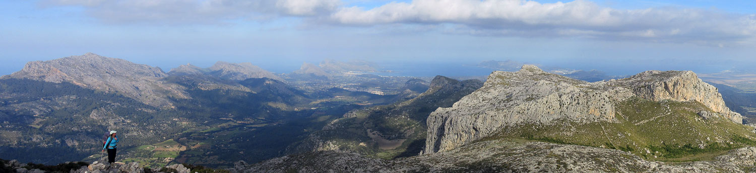
Day 1 Pollenca to near Lluc We took the bus from Palma to Pollenca (the buses are excellent on Mallorca) and filled our MSR stove up with unleaded at the petrol station in Pollenca before we started walking at about midday. We immediately took off on an alternate high level route over Puig Tomir to the east of the GR221 piecing together route descriptions from the Walking in Mallorca guide and the Alpenquerung website. This was an excellent choice for us in good weather with about 1000m of ascent but following trails the whole way, taking us about 7 hours. We had good views over the north of the island to Cap de Formentor. There was a short step down rock with via ferrata cables on the descent. The water source at Coll des Pedregaret was dry. However the source at Ermita was good– we camped near here.
2023- This was my last day and I hiked the normal GR221 this time. Its still a pretty pleasant hike staying lower down once north of Lluc and good water at a river about half way along.

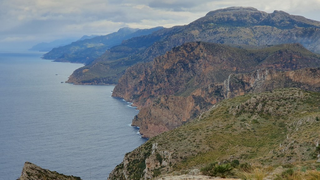
Day 2 Lluc to Cuber We descended to Lluc monastery and hung about here for a while as the cloud was down, with drizzle and the winds looked strong higher up. Eventually we took a lower level route round the peak of Massanella to the south- again piecing together routes in the Walking in Mallorca guide. This turned out to be fun as it included the extraordinary Canaleta de Massanella- a mountain canal built in the 1740’s to take water down to the towns on the eastern plains. The hiking along the canal was narrow and exposed in places with the sound of gurgling water under our feet.
We crossed back onto the GR221 near the Col des Colums (plenty of water in a river on the south side of the col) and then descended down beside the concrete viaduct (more water) to Cuber reservoir to camp.

2023- The trail was icy in places alongside the viaduct to Col des Colums and snowy above so I again took the Canaleta route. This time I hiked all the way from Soller to camp just north of Lluc in the trees.

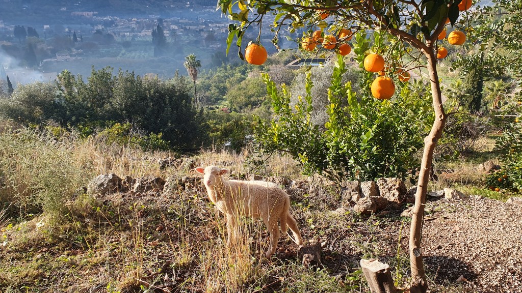
Day 3 Cuber to south of Deia Today was a bit longer but superb and with lots of variety. An easy walk led to the Col de L’Ofre then we descended down the cobbled steep gorge of Barranc de Biniaraix to the town of Biniaraix. Water was available down the gorge in a few spots. Then we hiked through attractive town streets to Soller (the biggest town on route including an excellent small gear shop) and onto Port de Soller. Onto Deia on lower level trails past olive orchards and oak woods. The ‘Finca’ of Can Prohom provided a great excuse to stop for drinks and cake!
We took water in Deia before hiking steeply up south out of town. The trail is not marked here but heads from the main road up a minor zig-zagging road just prior to the Hotel Es Moli. We found a campsite on a terrace just before dark next to an old shepherd’s hut and water tank- maybe 45 minutes above Deia.


Day 4 Deia to Valldemossa A short hike today up to about 920m then on the ‘Archduke’s trail’ – a cobbled wide path right along a ridge with a vertical drop off to the west and views down to the coast- superb! From there we dropped steeply through oak forest on a good trail into Valldemossa. There was a water trough on the lower slopes.

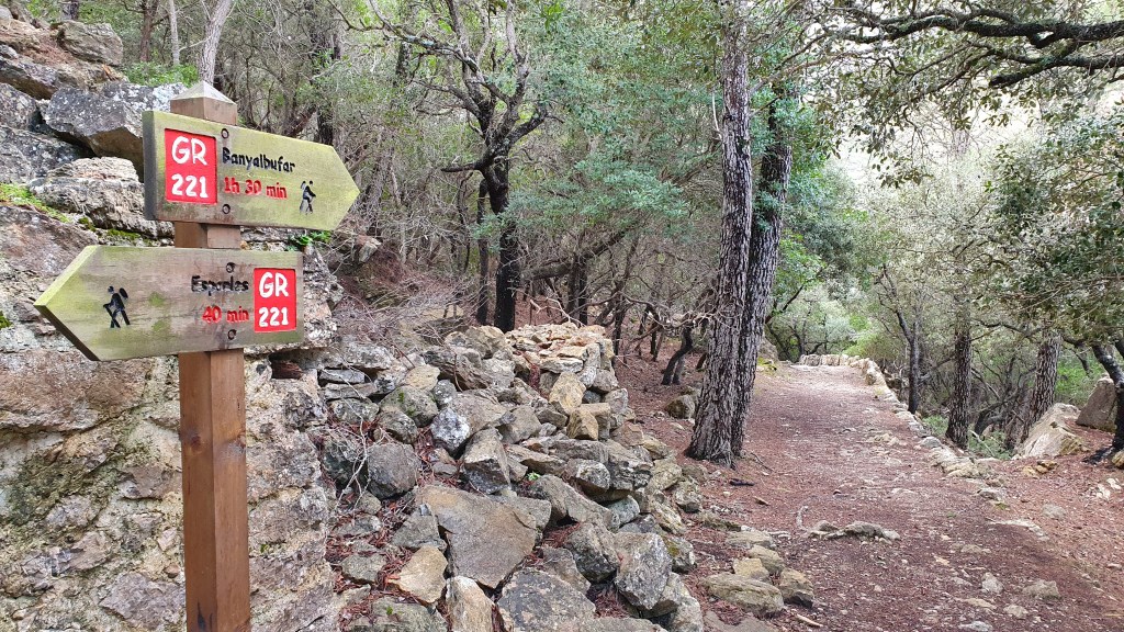
Day 5 Valldemossa to south of Estellencs Today was a long one but over less steep terrain. We stayed high on jeep tracks avoiding the town of Balyalbufar on a newly signposted trail. There is a good water source in town in Estellencs as the road crosses the river. Heading south from the town the trail mostly stays on the coast side of the main road through forest and we found a campsite on terraces beneath the jeep track trail after about an hour.
Day 6 Estellencs to Peguera This was our final day on an alternate described in the Cicerone guidebook but now the signposted Gr221 trail on the ground (well at least to the town of Es Capdella). Hiking on below the road was easy on jeep tracks before the trail zig zags back up to the road and back north along it for a few hundred meters. There is a water tank at the trailhead on the south side of the road. The signposted trail then climbs a jeep track steeply up the hill to the new refuge ( Sa Coma d’en Vidal) under construction. It looks like it will be ready soon….
We were hit by high winds and cloud here as we climbed further on a jeep track to a high point and nicer trail down into the Galatzo valley. Just above where the trail flattens out onto jeep track again there was a good water tank with a pipe flow into the tank.
Easy hiking on jeep trails then tarmac all the way into Es Capdella town with a store. We followed the Cicerone guide description from here past S’Estrat but it looks like there is a new trail that runs beside the road all the way to Peguera.


2023 Andraxt to Estellencs
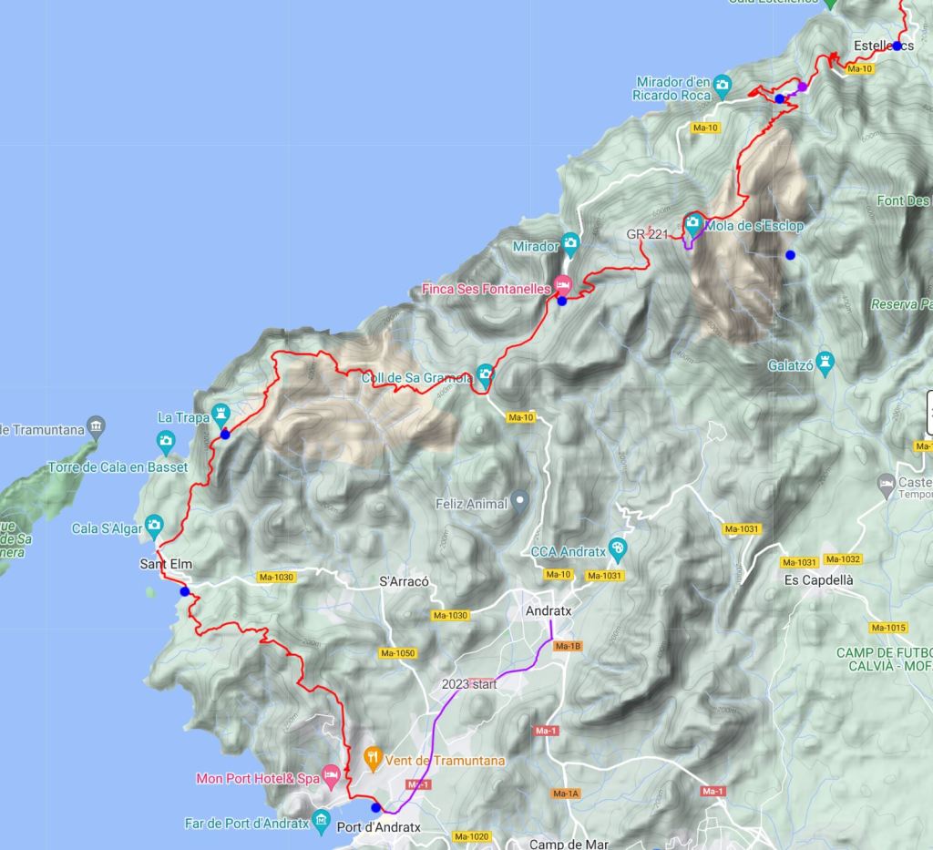
In 2023 I started in the town of Andratx and walked a cycle path 3 miles to the normal start at Port d’Andratx. Not out of choice but there was a cycle race on and the buses to the port had been cancelled for the afternoon They take their road cycling seriously here in Mallorca!

There followed a pleasant walk along the coast past St Elm with jeep tracks and trails undulating over the high ground between. Scenic coastal views particularly to the Dragonara island with its steep cliffs and lighthouse. I camped at La Trapa, an old Trappist monk site that is being rebuilt as a refuge. I couldn’t find anywhere to collect overnight water at St Elm and eventually saw someone cleaning their car with a water hose- problem solved!


It poured with rain all night and most of the next day which curtailed the enjoyment a wee bit but this was still a cool coast and mountain hike in a fairly wild part of the island. I made it to Estellencs which could be summarized as being shut, so I hiked on using easy going trails to the lovely coastal town of Banyabulfar and arranged a Airbnb to dry out.

This looks great! Thanks for the inspiration. We’re always looking for stuff we can do in the winter time.
LikeLike
Thanks yes, it is a great short winter hike on a lovely island. We are heading back to the Colorado plateau in October to hike for 3 weeks and am enjoying reading your Hayduke journal!
LikeLike
Thanks for sharing your hike! I’m thinking about hiking this trail in late Feb and finish in early March but I’m not sure about weather, how bad can it get with winds and rain?
LikeLike
Hi Urska,
Late February is when we hiked the trail and we had pretty good weather but you can see from the photos we were hiking in fleeces and leggings most of the time. It heated up to maybe 20C on the last day towards the south coast. We had one morning of rain only. I am not sure how bad it can get, but I would happily go back to Mallorca to hike at that time again. But take a fleece and waterproofs just in case!
If you decide to go for it have a great hike!
Brian
LikeLike
We intend to walk the gr221 trail in late april/early may this year. how do you think wild camping will be possible along the entire route?
LikeLiked by 1 person
Hi Radek, I haven’t been out at that time of year and it may be a bit busier than we have experienced in winter. I think though if you are careful where you camp away from towns and practice ‘leave no trace’ then wild camping should be possible.
LikeLike