
Idyllwild 8th May. After two days of low cloud in the village of Idyllwild and a life of excess and gross quantities of food, we were keen to get back on the trail. A stiff 2,500ft climb with bulging rucksacks took us into snow and then cloud to Saddle Junction at 8,000ft on the PCT itself. Deep snow covered the ridge ahead and cloud would descend then break up to give fleeting glimpses of the mountains ahead. The path was completely obscured by snow and we followed footsteps backed up by compass bearings. The footsteps were Brian Sweet’s who left the village a few hours before us and whom we hoped to catch up with. We had been waylaid by hitchhiking a lift from the village to the road end. The driver, John Holt, upon hearing we were Scottish, took us to see his neighbours who were in the middle of organising a Scottish wedding. They were a bit surprised as we were to suddenly be introduced by Mr Holt – who then proceeded to drive off in his car (with our packs still in his boot!!) After about an hour of embarrassment Mr Holt was tracked down and we managed to return to the trail.

We followed the ridge for a mile or so before the path then contoured round the steep west flank of the mountain. In summer this must be a straightforward section, but with no visibility and deep snowdrifts we wandered around for a couple of hours before being able to follow traces of the path. An hour later the cloud lifted to give us views around the mountain and we heaved sighs of relief to see traces of the path ahead. Continuing around in deep snow we were soon joined by Brian whom we had passed as he was sitting out the cloudy weather. More deep snow with traces of path kept up till Strawberry Camp (a summer campsite which we found by stumbling upon a signpost half buried in snowdrift). From then the three of us plodded along in even deeper snow following map and compass only, frequently sinking deep (“post-holing” as the Americans call it) into the snow around covered boulders, trees, bushes and streams. We were around 8,000ft and in the sun whilst below we could see a carpet of cloud engulfing the Los Angeles valley. We later stopped, forced to camp on snow near a spot called Deer Springs.

It was a bitter night; cold enough to freeze the water in our bottles and to solidify our boots such that we had to slowly thaw our gear and ourselves the next morning before moving on. Unfortunately the snow had also frozen to a hard concrete consistency and we slithered around on the surface with our lightweight trail shoes. Traversing steep slopes each of us had occasion to use their ice axes in anger to break falls, so we soon decided to move in line with the leader chopping out steps in the snow with their axe. This was a tiring and slow method so we all took turns to lead the way. As the day progressed the strong sun gradually melted the snow and we were able to kick steps into the surface with our boots, and it was with relief we made it to a spur of San Jacinto called Fuller Ridge. Although this was snow-covered, too, we were able to follow the obvious feature of the ridge and within 3 hours we hit upon a logging-road clear of snow which we followed to regain the PCT.
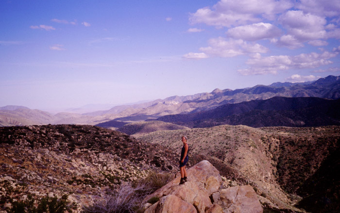
We had made 9 PCT miles only that day but were none the less exhausted. As we collapsed in a lovely viewful camp that night, cloud filled the valley, sitting at an altitude such that we could see above the cloud to the snow-capped San Bernardino hills and below to the lights of the freeway.

From the top of Fuller ridge, our next day involved a convoluted 20 mile descent of 9,000 feet to the San Gorgonio Pass and Interstate 10 which connects LA to the east and Palm Springs. At many times in the course of our walk we had reason to curse the designers of the PCT trail sections. But none more so than here. Our target Interstate could be seen all day below us but our path did anything but go down directly as it swept out the biggest set of zigzag’s conceivable – each traverse being sometimes as large as 2 miles and occasionally descending at such a mediocre angle as to seem to be going uphill. The obvious solution would be to take ourselves off the PCT and descend directly but the terrain conspired against this – scrub bush, manzanita, cactus – all meant that progress would be painful as well as slow. But the trail was a good one and it eventually took us down the slopes safely.
By lunchtime we had made it down to the valley floor and a small water tap built by the PCTA, we were extremely grateful for this godsend in the dry dusty valley. A good spot for lunch and to congratulate ourselves on completing the longest descent of the trip. Also for a rest- Martina had hurt a shin muscle in the walk and was applying anti-inflammatory gel as well as bandaging.
Eventually we moved on to tackle a crossing of the San Gorgonio valley. A strong wind channelled through the valley from the west. This was the stuff of the spaghetti western, tumbleweed hurtled past us bounding over the dusty valley floor. Our throats dried out with dust adhering to the walls of our mouths. We struggled westward into the teeth of the wind, each lost in our own world. Above the noise of the wind we could hear the racket of the Interstate as we approached it. Juggernauts rumbling past on a mission to supply LA and Palm Springs. Our route used a tunnel under the road and reached a low point of graffiti, junk, twisted metal and sun faded ‘Budweiser’ cans.
Beyond, a few shanty houses were spread out away from the road and we made our way through them on rutted tracks. On planning the day we had hoped to find a store here to stock up on ‘luxury’ food, but our hopes were soon dashed after Martina stepped up to house for information and was sternly rebuked by an unfriendly local. People liked their privacy here as, each house was surrounded by a large fence and usually some kind of sign indicating a large dog with a dislike of strangers was resident. Garden displays were of the trashed car and TV-screen variety. We pondered on why people would want to stay out here and barricade themselves up like this- perhaps they had no choice as it would be cheap land near to the work opportunities of Palm Springs. It evoked thoughts of ‘gun-totin’, checked-shirt, bristly residents driving us off their land.
With no chance of buying food we headed on towards the slopes of the hills to the north. Here we entered the San Bernardino mountains, a more rounded set of high hills up to 10,000ft and surrounding the town of Big Bear City where we had visited prior to starting the trail. Our first taste of these hills though was the swooshing of wind turbines. They filled the hillsides here in huge clusters of varied designs. We camped next to a wind-farm – not out of choice but because we were tired and could not go any further that day. In fact the sound of the turbines became a background aural wallpaper, especially to our tired bodies and we slept soundly that night.
It was a dry camp though, and we sped on quickly the next morning towards our next water source at Whitewater River, a long 13 miles from our last water. We found a watch on the path and carried it with us as we had a good chance of meeting its owner. He soon appeared ahead of us down at the river valley, it was none other than Brian Sweet again, he had camped only one mile ahead of us last night. We all stopped for some shade under trees at the river and Martina and I managed to bathe in its cool waters. The feeling of refreshment was incredible and such a tonic from the hot dusty walking of the morning.

The river formed our route for the next few miles, climbing up beside its snaking path with many crossings from side to side to find the best walking terrain. Our destination that night was Randy’s Hostel, a house constructed by Randy and friends well away from any roads in the San Bernardino mountain forests. Randy had posted adverts along the trail so we had been well informed that, for a cost, he would supply camping space, meals and showers – a great incentive for us as we climbed higher in the evening. The hostel didn’t let us down, both Randy and his friend Brad were both very welcoming and the hostel had a lovely cool setting in amongst cedar trees. They explained that they had been battling with the landowners for their right to remain in the hostel and were keen to argue their case to us. It sounded like they had been given a verbal agreement to build on the land but did not own any of it themselves.

There was a fair collection of hikers staying there that night; Brian Sweet, Mike, Lynne, Tony and ourselves. Randy was able to get a weather forecast which predicted snow and storms for the next few days and we each had to decide what to do next. We agreed with Brian Sweet that we would push on hard to make big Bear City, a long 33 miles away, rather than have to rest here for a few days so early in the journey. The others decided to stay put for the worst of the storm.
We left Randy’s early the next morning amidst darkening skies but helped by the fact that we were in deep forest that provide us with much shelter. We made good speed throughout the day and had covered 20 miles before the first snow fell on us in the evening. It then came down steadily and heavily – Brian stopped to camp but we continued for another three miles to stop at Arrastre, a snow covered summer campsite with a water supply. Throughout the night the snow piled up and wind would gush up the valley, swooping against the trees causing the snow to fall against the tent with a dull thud. It was a winterscape scene we awoke to in the morning. Although our fingers were numb with cold, fumbling with the stove and packing the tent, the scenery was beautiful with snow covering the ground and all the trees around. Brian wandered by as we were having breakfast and we walked off with him for Big Bear City, about 9 miles away. As we cleared the forest, we had the extraordinary sight (for us) of snow covered cactus.
One thought on “PCT Southern California-Idyllwild”