Needles to Hanksville

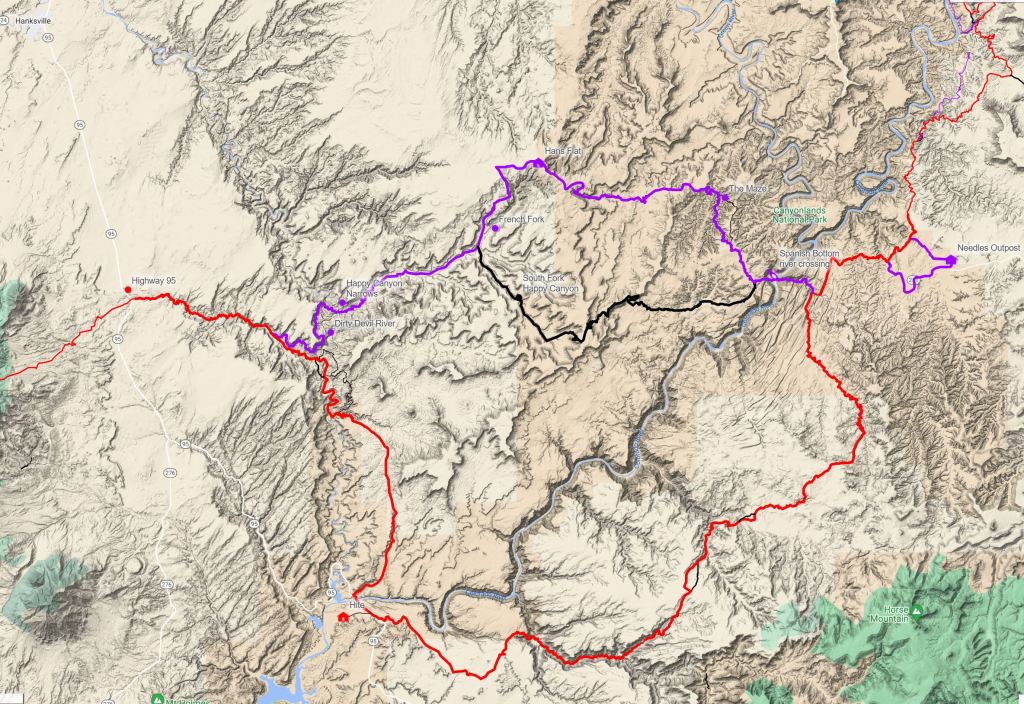
On this section we were mostly on an alternate to the Hayduke Trail to take in an area of very remote and intricate canyons called “The Maze” which we hadn’t seen before. In 2014 we took another alternate and what both have in common is that from Needles in Canyonlands National Park, we end up at the Colorado River at a place called Spanish Bottom. From the north bank of the river we climb up again over remote plateau and end up in the well named Happy Canyon and then cross the even more appropriately named Dirty Devil river (a very muddy tributary of the Colorado). Credits for the route go to Jamal Green who describes it on his excellent Across Utah website.

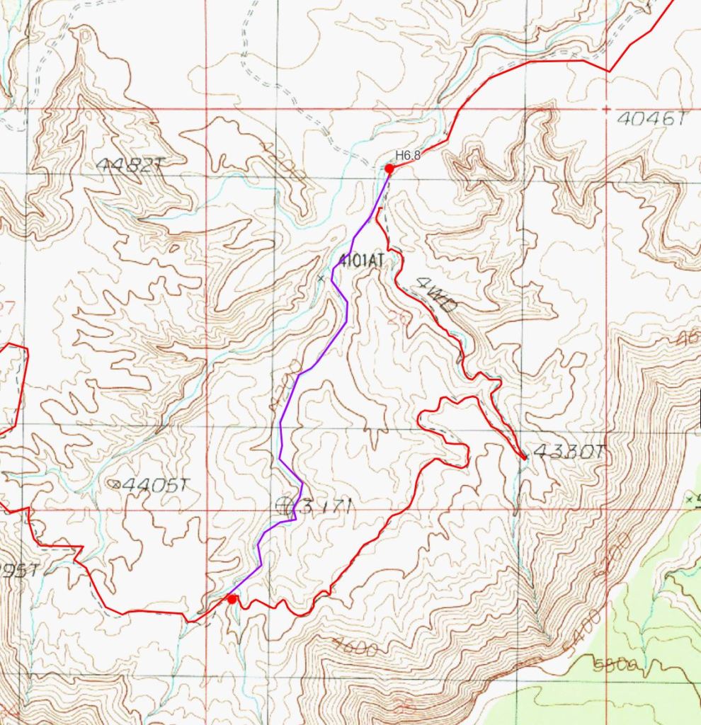
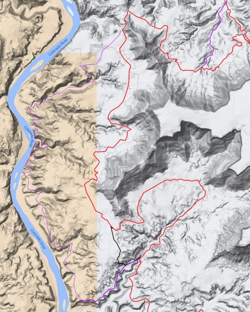
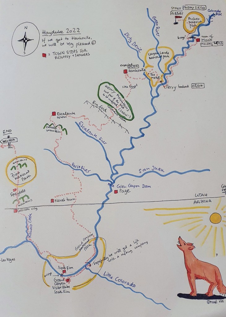
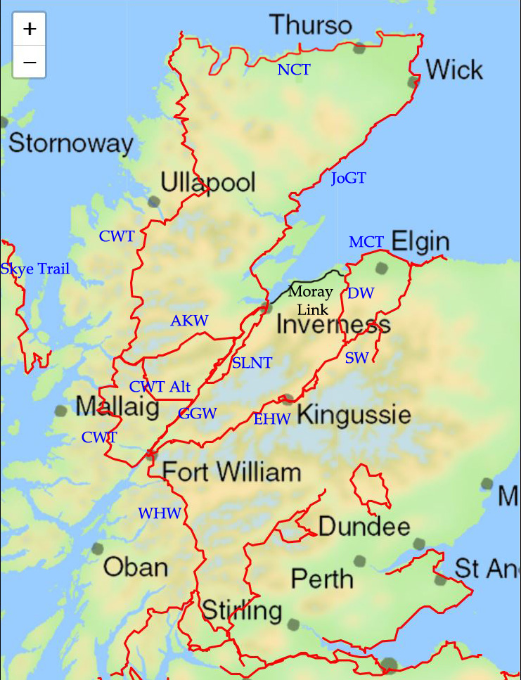
The map below has an overview of the routes; Red=Hayduke, Purple=2022 Alternate via The Maze, Black=2014 Alternate via Ernies Country and South Fork Happy

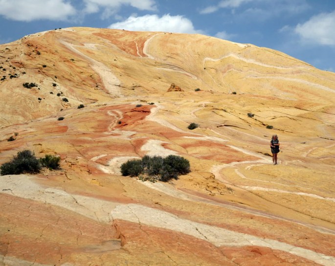
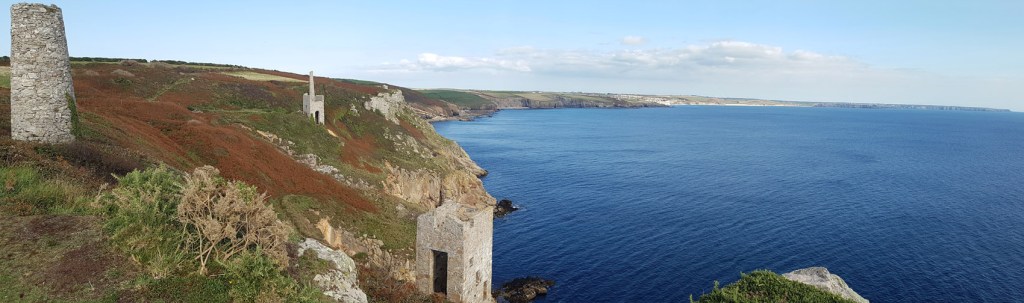
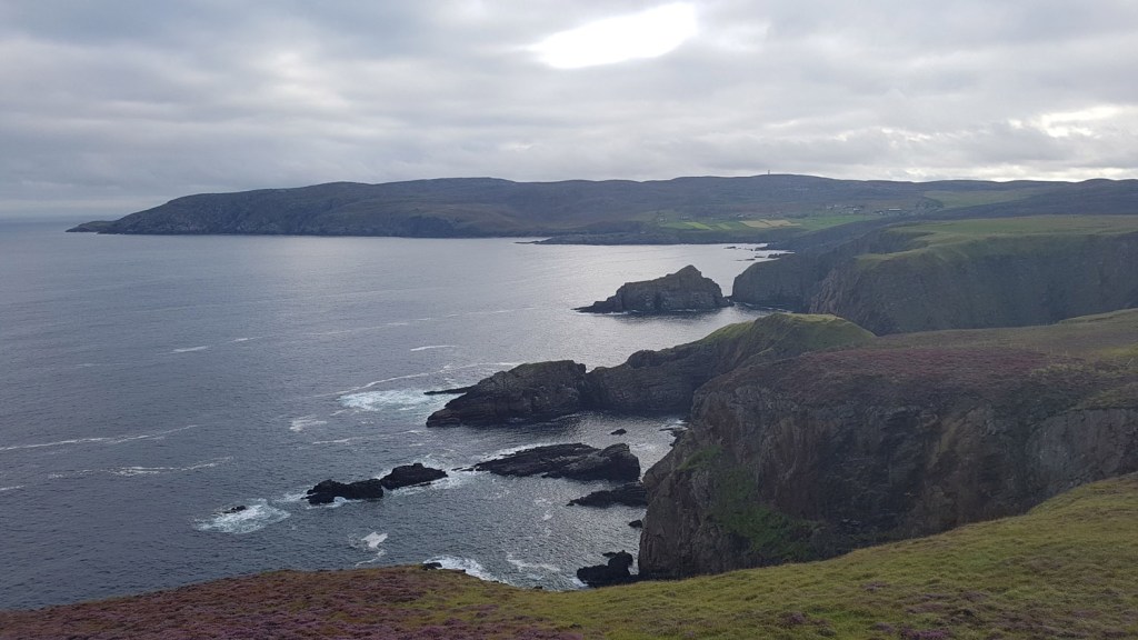
The Needles area of Canyonlands is mostly known for spiky stripy rock formations but it also has a sunken valley known as a graben called Cyclone Canyon which was a cool place to hike. This is not made by water erosion like most canyons but by a collapse of underground salt deposits.

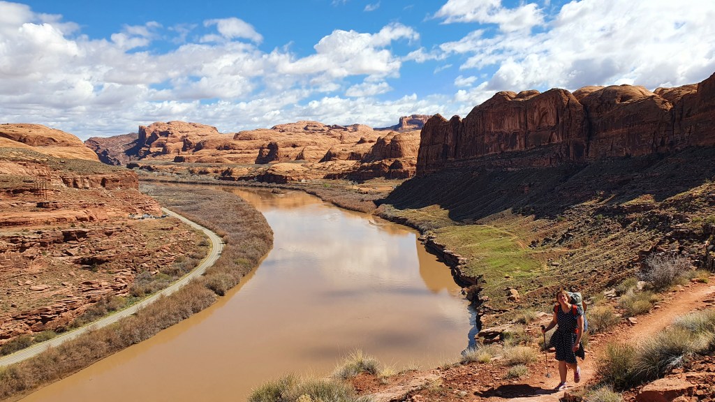
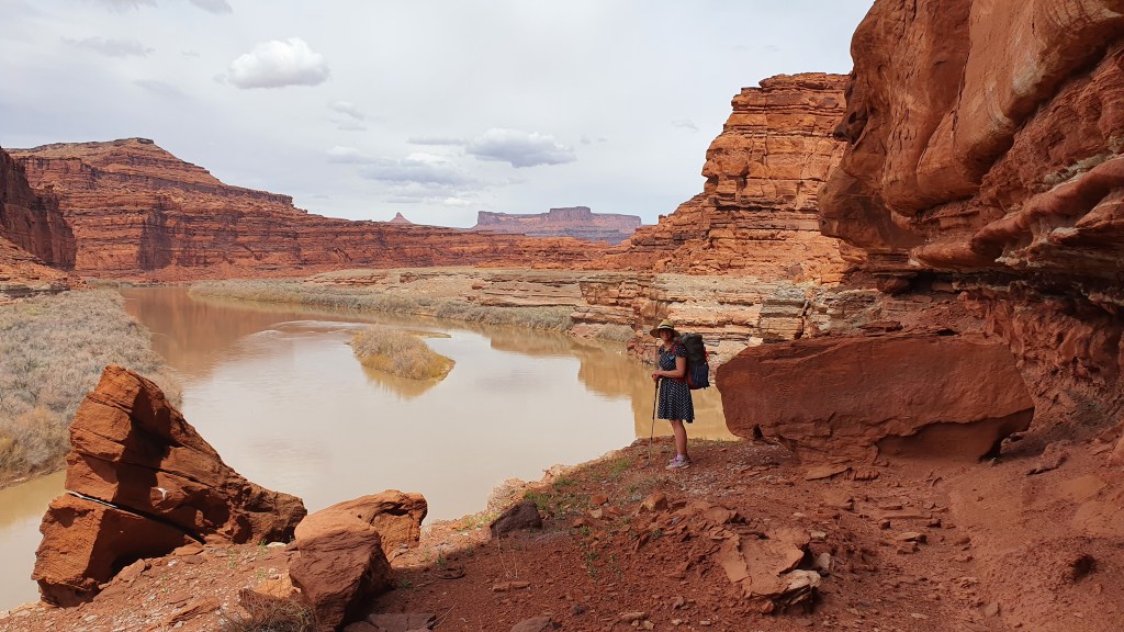
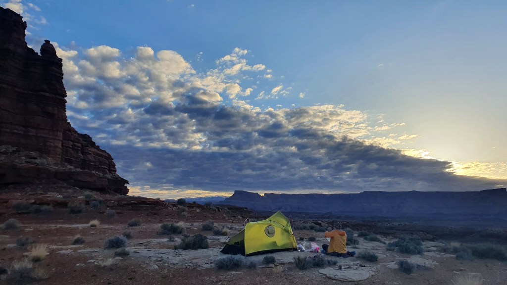
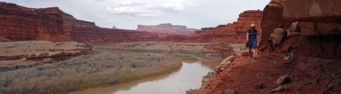
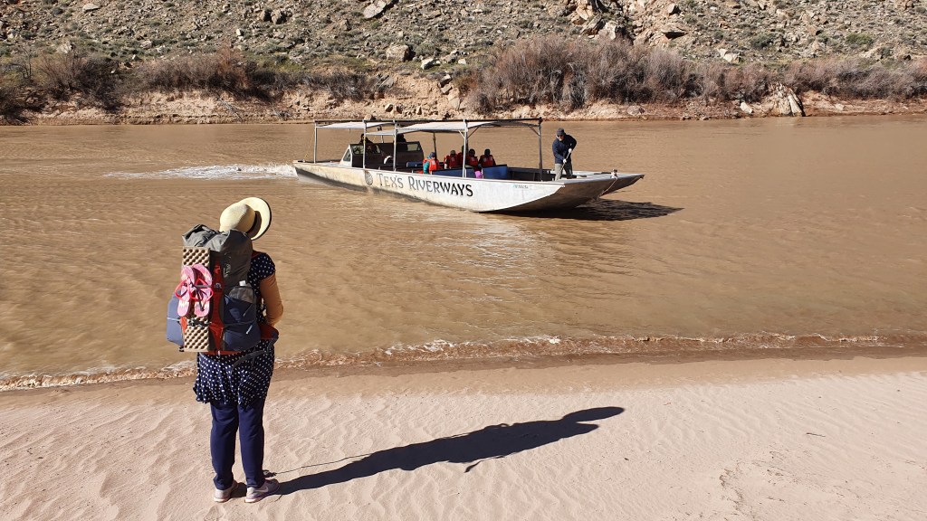
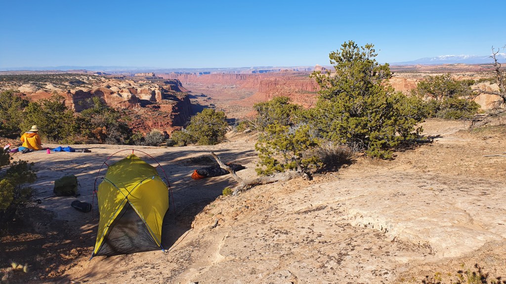
We camped near the south bank of the Colorado River on the first night. Brian had arranged for a ferry operator to pick us up at 10:00 and take us across. They were taking hikers from Moab to the opposite northern shore and that all worked out very smoothly.

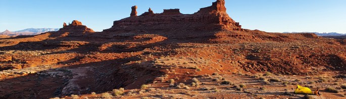
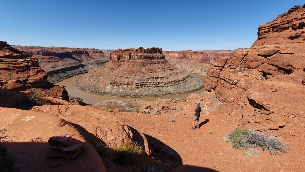
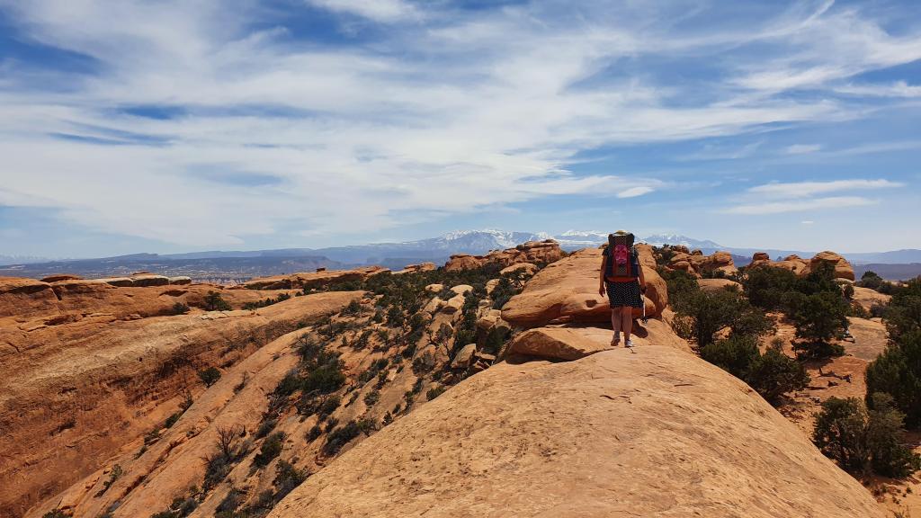
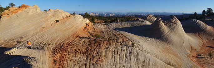
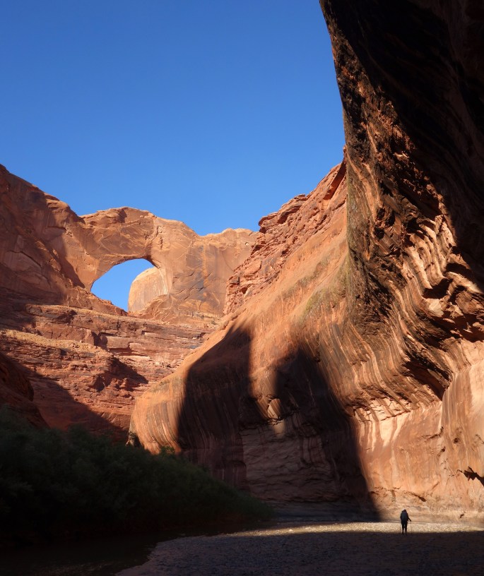
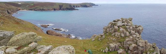
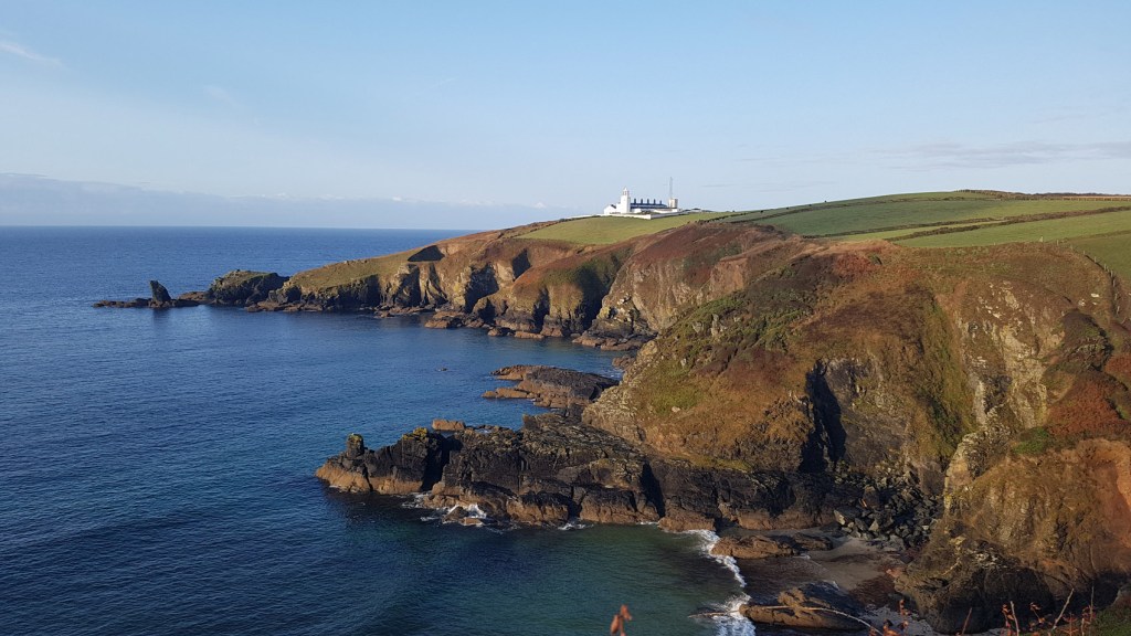
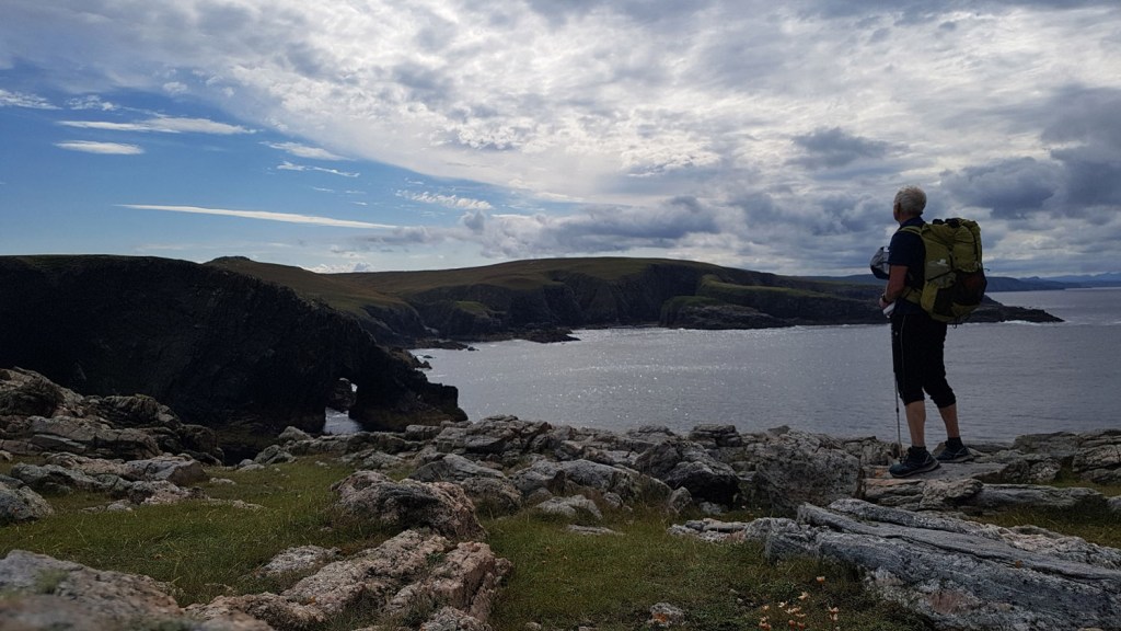
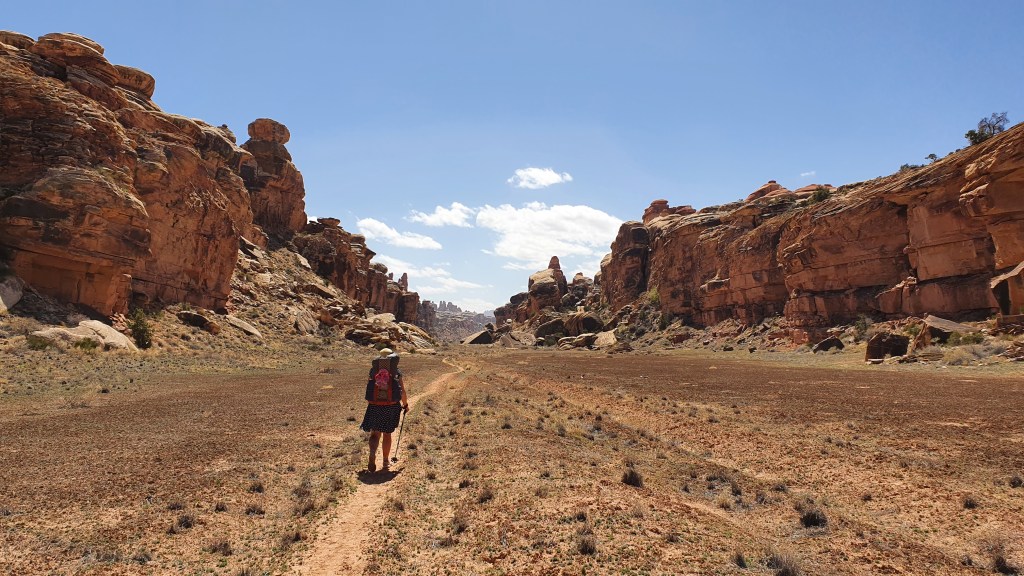
From there we climbed a steep trail up 1000 ft to a place of rock spires called the Dolls House. The trail was made in the 19th century by sheepherders to allow their flocks access to the river. We followed some jeep tracks north across open plateau to reach the edge of ‘The Maze’ at a place called Chimney Rock and the descent down a cairned route into The Maze was tremendous.

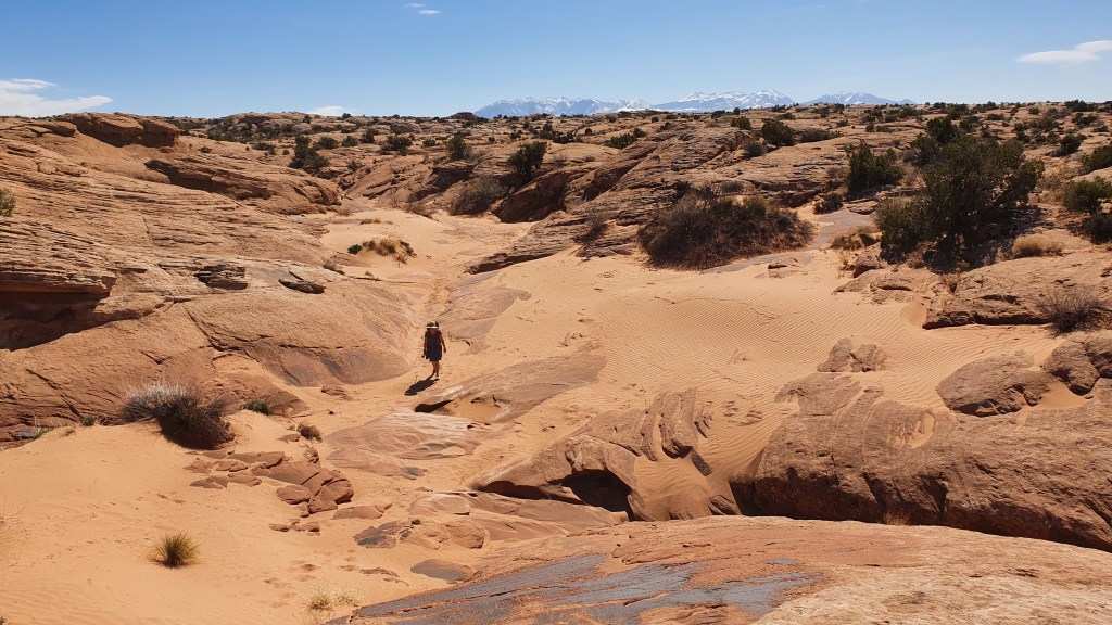
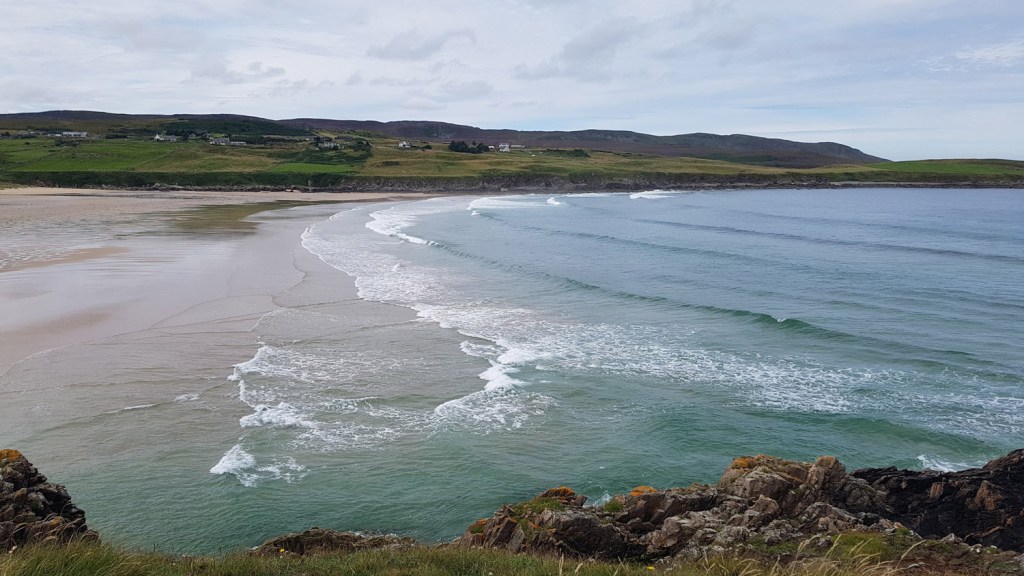
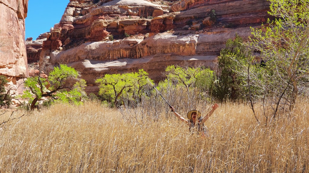
Inside The Maze we saw green cottonwood trees for the first time and the character of the landscape was less severe, more gentle. There was water! Not flowing but emerging in small clear dips in the sand.

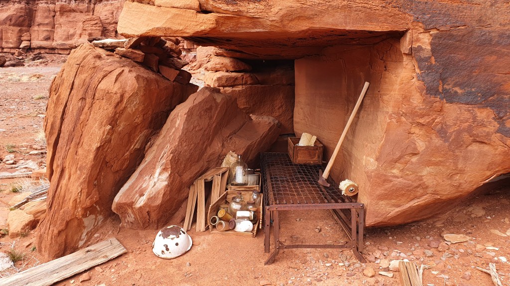
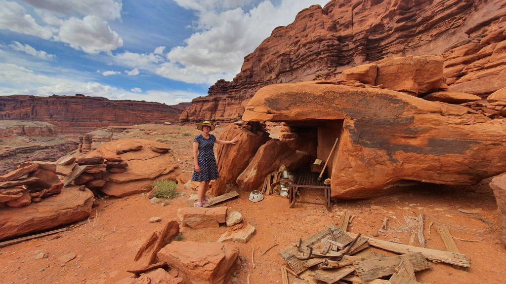
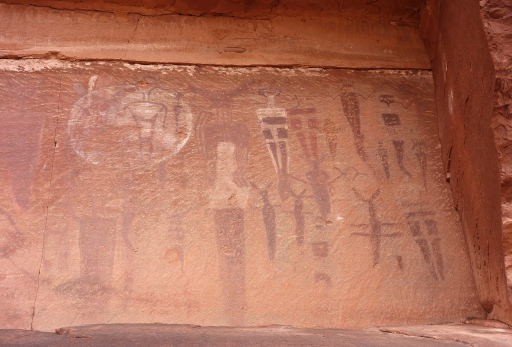
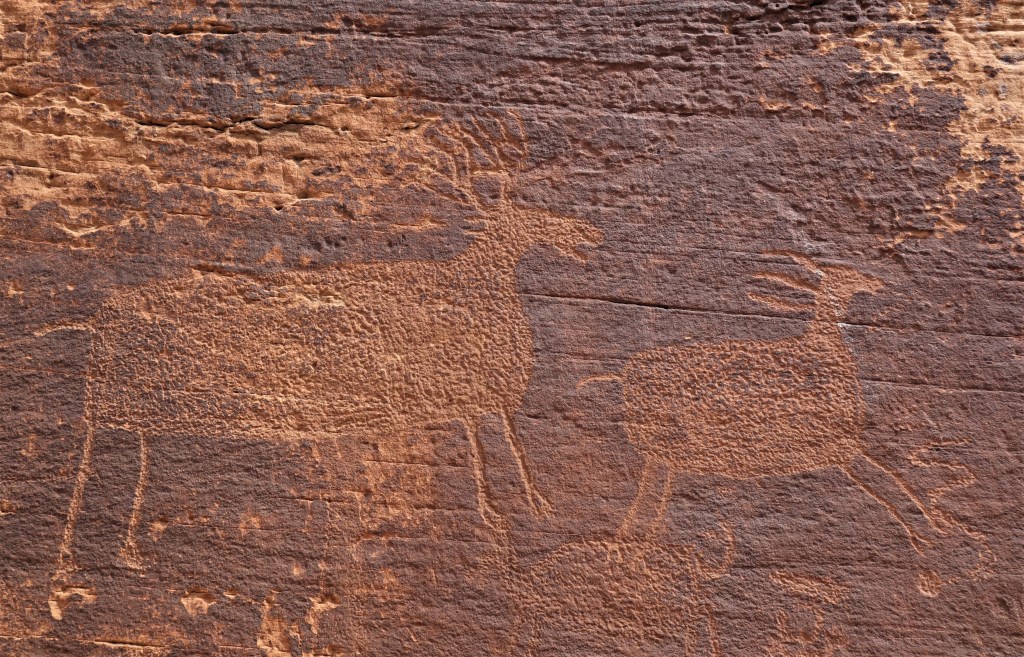
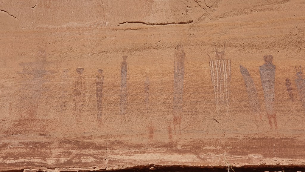
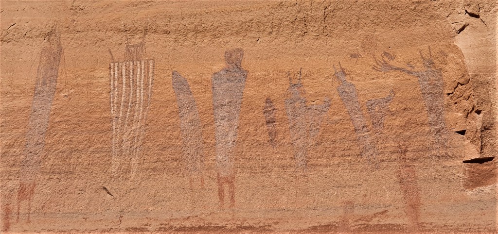
We were not the only people to find The Maze hospitable as seen in pictographs at the Harvest Scene panels lefts by people variously referred to as Fremont or Basketmaker people.

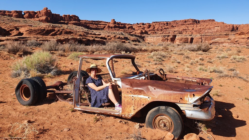
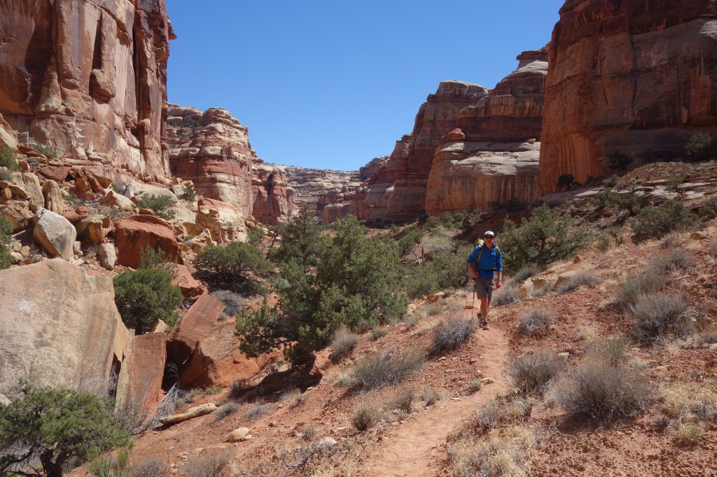
From the Maze we had a few miles on jeep trails over a plateau called Hans Flat, named after rancher Hans Andersen who ran cattle here. We were able to pick up some water here at remote park visitor centre.

Then we descended North French Spring Fork of Happy Canyon. Finding the top of the descent down the steep canyon walls was quite exciting as it involved a fair bit of route finding (no trail here). Along the way we came across three black donkeys who live happily down there in a green(ish) valley…… they took one look at us and ran.

After the donkeys we got onto another 100 year old stock trail down, down, down a weakness in the cliffs until we hit the floor of the fork into Happy Canyon.

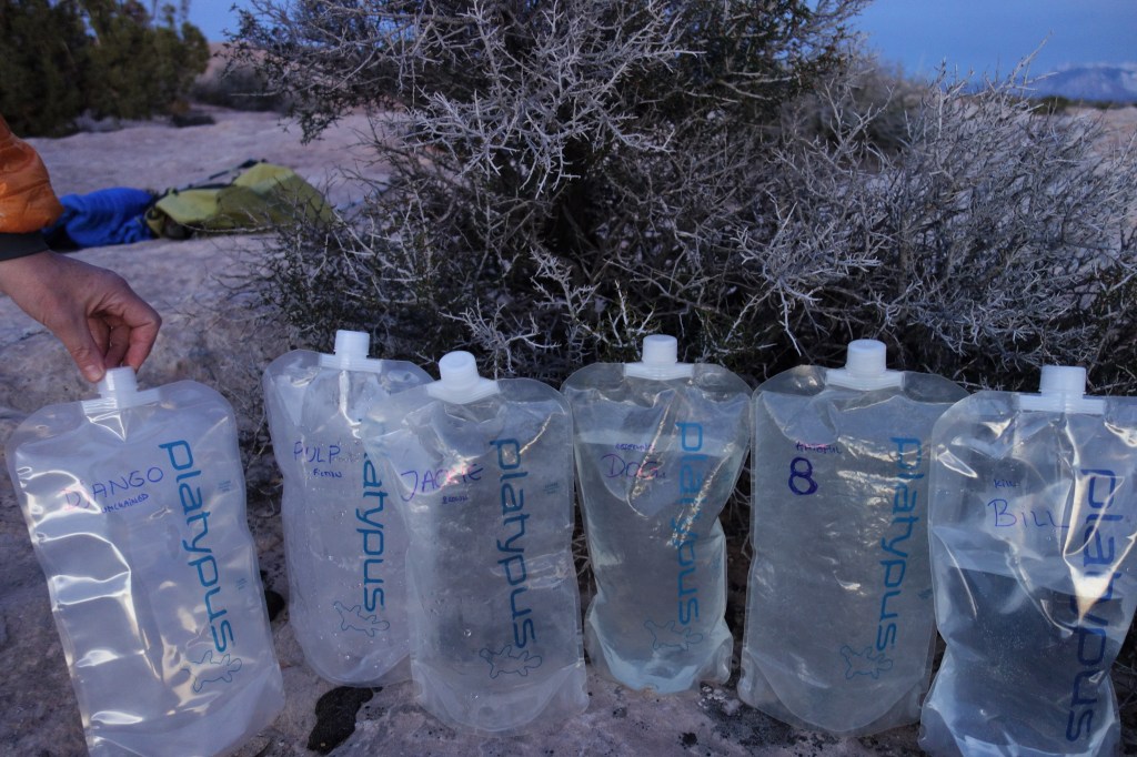
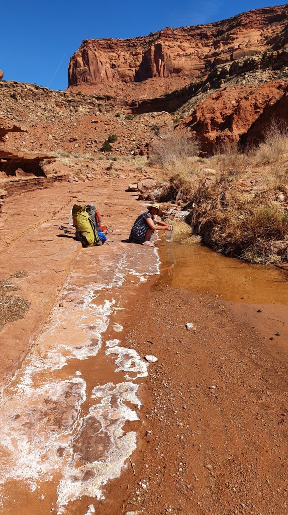
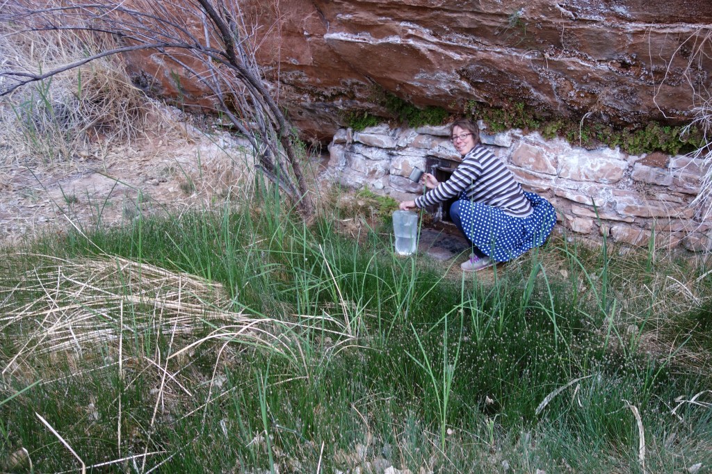
Happy Canyon had water! Yes, in the pic below this is a delicious clear (once the tadpoles and mosquito larvae have been shoo-ed out of the way) first rate drinking water. Ignore the white rime. That’s just minerals deposited as the water evaporates…

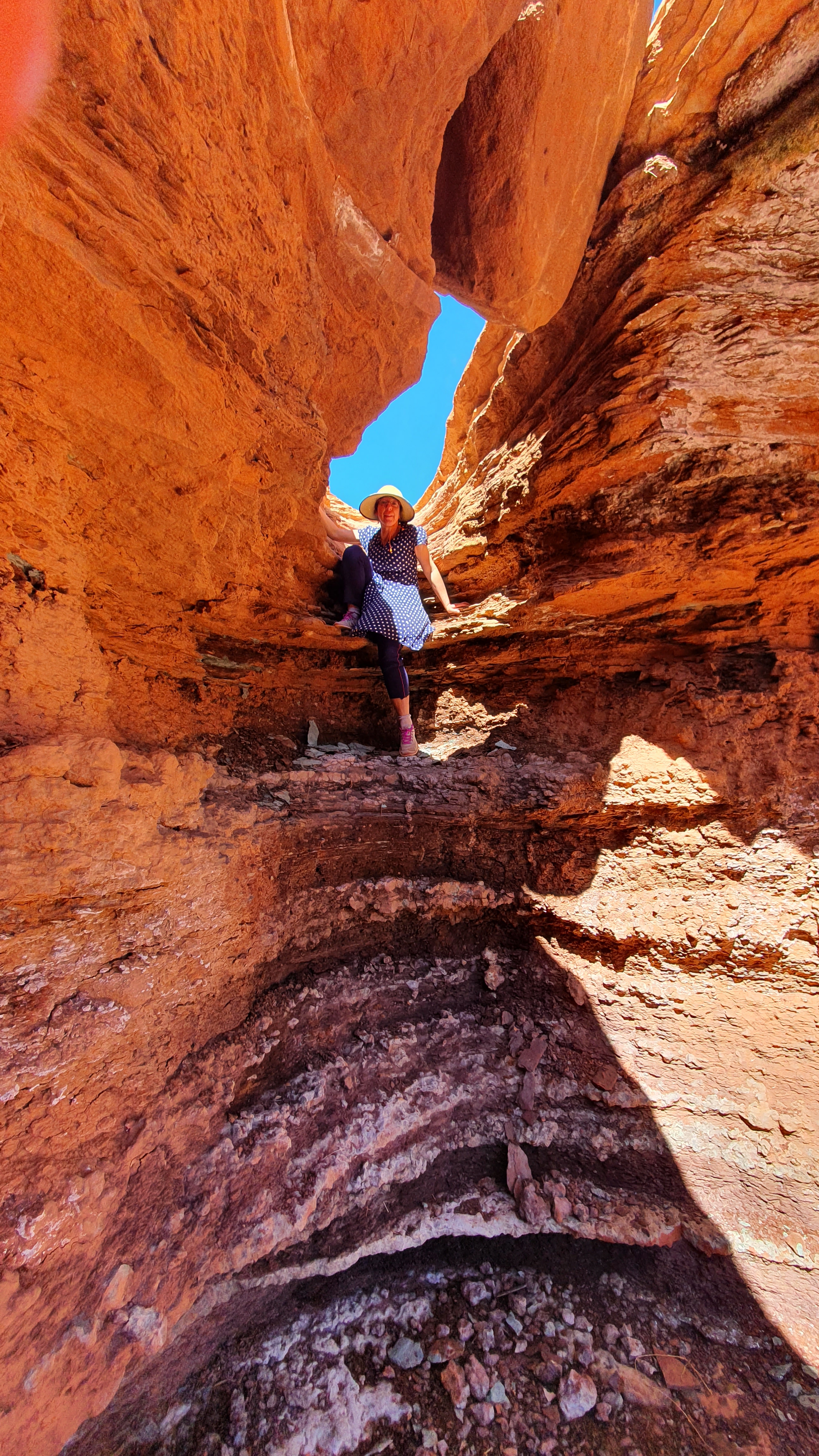
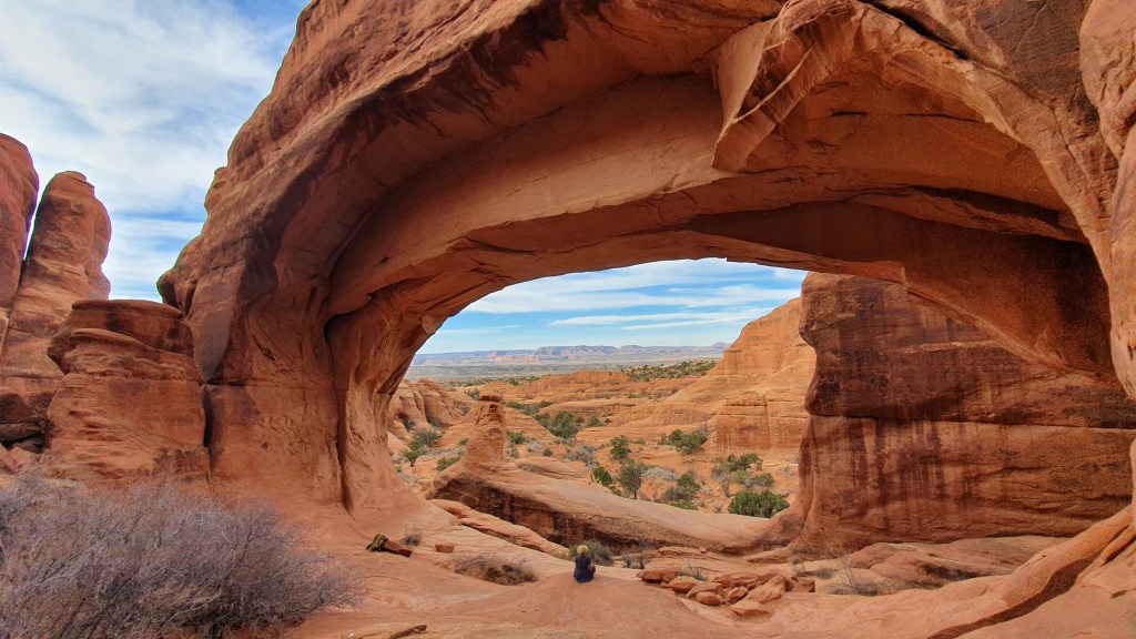
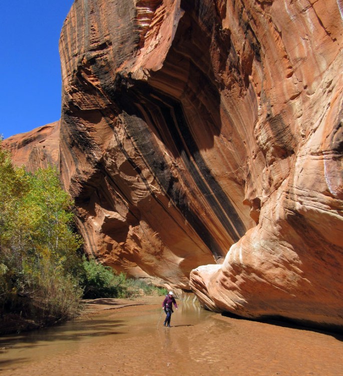
The second best thing about Happy Canyon, after the water, is that it turns into a slot Canyon for the last mile and a bit. So, so beautiful!

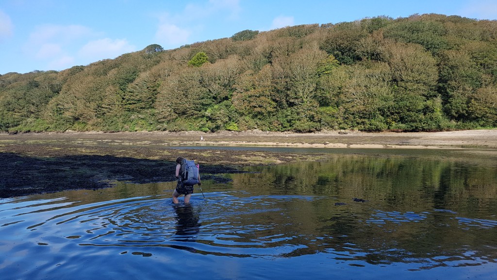
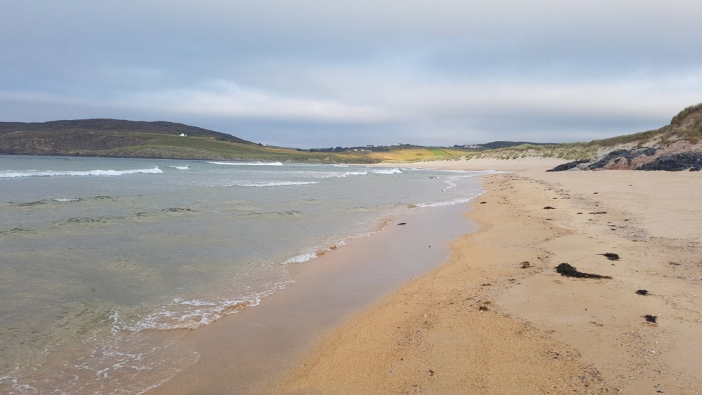
Happy Canyon narrows end very suddenly when meeting the Dirty Devil. This is a long river that goes through layers of rock that produce a lot of very fine silt (it also has lots of agricultural run off higher up)…so it is muddy and its bottom is very silty. Not much fun to cross and even worse to drink.

We decided against drinking it though as we pushed on to Poison Spring Canyon which, despite the name, had a wonderful clear spring.

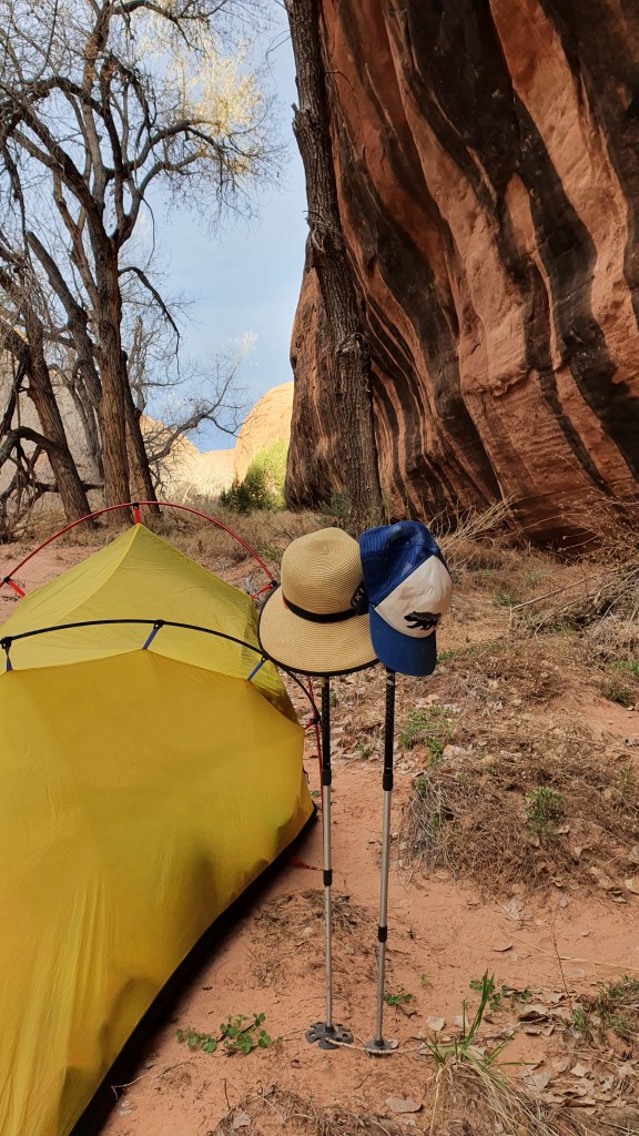
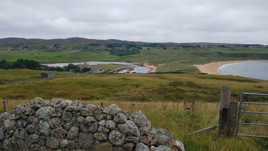
Now we have come over 180 miles and there are some signs of wear! Brian has taken to wearing his socks upside down because the sand has eroded the soles! There are also some blisters and we are now in the tiny town of Hanksville, resting up and preparing for the next section over the Henry mountains to the town of Escalante…..

A few more photos…

More pics on our pbase site here

Hiker notes

Route We took a northerly alternate from the Hayduke over the Colorado River at Spanish Bottom, through the Maze, Hans Flat and Happy Canyons to join the Hayduke at Poison Springs. See here for overview map.

Needles visitor centre to Colorado River – We saw no water on the trail from Big Springs down Cyclone Canyon then Lower Red Lake. We took water from the Colorado.

Maze – Standard descent from west of Chimney rock to Pictograph canyon – small pothole on scramble descent and small potholes at canyon bottom about where marked by Kelsey as a spring.

Maze- Wash north of the Harvest Scene, on the west side of the canyon junction -small seep flow

Maze – Foot of the Maze Overlook trail – Good water in pools with a small flow.

North Trail Canyon – Small pothole just before steep zig zag exit. We didn’t notice any water between Maze Overlook and here.

Hans Flat Ranger Station- Sells gallon jugs and open between 8 and 4.30.

North French Springs Fork – Medium pothole of water in wash above steep constructed trail descent. Well used by feral donkeys though and we didn’t take.

North French Springs Fork- Constructed trail descends steep section round a nose to the boulder filled wash at bottom and then continues criss crossing wash to easier ground after boulder section. Makes for a relatively easy passage.

North French Springs Fork- Slickrock pothole area down wash mentioned by Jamal Green was dry.

Happy Canyon- Small seep 1 mile below French Springs Fork junction. Good pools and seeps 3 miles below. We also saw these in April 2014. Happy Canyon narrows had some small potholes which may be better than the muddy water in the Dirty Devil…

Poison Spring Canyon- Good flow about 1 mile below and 2 miles above the spring.

Moab to Needles Canyonlands NP

Two nights rest and a lot of rain in the town of Moab and we are off again. We are following the mighty Colorado river. In 2014 we paddled down it. This time we are walking in and out of canyons, over ridges and along ledges.

At first we still shared our trail with mountain bikes and ATVs. Although this is very remote country, there are some one or two homes out here and the people who live off grid are usually very hospitable. Like Tom and his tortoise Kobe. He shared his drinking water (which is hauled in by 4×4 over some fearsome rugged terrain) and some good stories about hikers that have come past on the Hayduke and ATV drivers he has had to rescue over the years. He also has installed a Frisby golf course on his property but we didn’t have time…

Although we are following the Colorado, we only stood on its banks with our toes in its water once. The rest of the time we were high above it on ledges and weaving inland to go around (and sometimes into) steep tributary canyons. There are still some areas used for seasonal cattle pasture (less so now after an ongoing long draught).

We passed by an old cowboy camp ‘Tangrens’, used by horsemen up to the 50’s I think. There was an old bedstead and tissue roll amazingly intact as well as some unidentified foodstuffs in jars… we were hungry but didn’t try!

Rustler Creek dryfall had a cool scramble under a chockstone

One of the best things in Canyon country is camping with a view of the landscape below at dusk and dawn. And in between the clear night sky and the complete silence…except when there is a cricket…or an owl…or a coyote. Then it’s even better!

After 4 days we arrived at Needles Outpost, a privately run campsite and store at the edge of Canyonlands National Park and we are having a rest day in one of they glamping tents. Comes with a hammock. Very relaxing! We picked up one of our resupply parcels here with food for the next section. So far we have come about 105 miles. Doing some kit repair and enjoying a hot shower before hiking on into The Maze.

Resting up in Needles Outpost before we head out again!

More pics on our pbase site here

Hiker notes

Route We followed the Hayduke but with a few alternates as described.


HT30.2 We did the Amasa Back alternative which was nice and recommended. We started at Kane Creek, where there was a trail from the Trailhead to a bridge over the creek a few hundred meters up from the Colorado River (the Colorado river backs up into Kane Creek making it awkward and muddy to cross). There is a steep scramble down from the high point into Jackson Hole on an old trail, but other than that it is trail or jeep roads with good views.
Stopped at Base Camp and chatted to Tom who kindly let us fill up with water as well as admiring the tortoise!
There were 2 river access points to the Colorado River for water south of Base Camp after HT4.5, see below.


HT6.8 This is Chicken Corner and hard to miss, see pic! We took a direct alt (purple line below) south up a mellow wash with a couple of 2-3m high scrambling steps to short cut the HT (red below) which is an indirect jeep road. Worthwhile- its shorter and more interesting than the jeep road I think.


HT11.3 We left the HT just south of the pass at HT11.3 for a grand alternative down Hermit Canyon based on the Kelsey Canyonlands guidebook. We then followed a lovely limestone bench above the Colorado River narrowing to a meter or so in places.

There likely was access to the Colorado River for water from the bench, both at the bottom of Hermit and at the first canyon south of Hermit, but we didn’t check either out so can’t confirm that.

There is also the cool Tangren old horse camp on the way (please leave everything in place). We couldn’t find the spring to the east of Tangren as described in Kelsey though, …. I have doubts that it still exists.

We continued on the bench along the rim to Lockhart Canyon. Here we thought we could cross Lockhart and continue south to connect with the Hayduke at Rustler Canyon. There was a small cairn at the rim of Lockhart looking like we could drop down into the canyon. However we didn’t fancy it, the top looked too loose and rubbly for us!

Instead we followed the rim of Lockhart east easily on the same bench. Continuing along the rim of the north fork back to the Hayduke at HT20.9 and the foot of the Nic Barth Lockhart Cliff descent and a big pour off (black line below). This Hermit alternate taking you above the Colorado River is scenic and varied. Email me if you want more info.

Overview map showing our Hermit Canyon route in purple along the Colorado river (Hayduke in red)


HT20.9 There was a small clear flow of water coming down a slabby gully within the first half mile south of HT20.9 but I suspect this would be short lived after the rain we had about 4 days before so I wouldn’t rely on it.


HT25.4 Lockhart had a good flow for about 1/3 mile

HT32.3 Rustler dryfall. there was a small pool just above the dryfall but but Rustler was dry below. The direct route under the chockstone was fun!

HT35.1 Indian Creek. Pools of water in this stretch but no flow.

HT39.3 ‘We hope so’ wash. About 1/4 mile south of HT39.3 there is a large pothole of water just under a small dryfall. We took a side route out to the Colorado River neck lookout (pic above). Nice view and a short diversion starting from 200-300m before the pothole in ‘We hope so’ wash. Would be a nice camp spot too…

Arches National Park March 2022

We are walking!

We hopped across the Atlantic from Glasgow to Denver and holed up in the University and all-round outdoorsy town of Boulder, Colorado, for two nights. Here we shopped for hiking food for 17 days and packed two boxes to send forward with supplies: one to Caleb at Needles Outpost just outside Canyonlands National Park and one to the post office in Hanksville Utah. We will hopefully meet those boxes again!

Winter was still lingering in the foothills of the Rocky Mountains near Boulder. Paths amongst trees held compacted old snow and the vegetation was parched. We went for a walk around the Flat Irons (rock formations above the town) in bright sunshine and cold clear air.

In the afternoon of the second day we returned the hire car at Denver airport: feet only from now on! A 45 minute flight in a bus size plane took us over the Rockies to Moab airport with one rucksack each, all our belongings within and 3 days food.

Moab Canyonlands airport. Baggage collection in the sun

We walked from the desert airport across Highway 191 and towards the Klondike bluffs, a wall of red rock formations at the edge of Arches National Park. A couple of hours on but still outside the park, we made our first camp, snowy hills to the East in the glow of the setting sun, the warm air juniper scented and the distant hum of unfeasibly large American trucks..we were back!!!

Now, three days later, we have seen many rock arches, tiptoed over prickly balls of Russian thistle (a sort of angry tumble weed with spikes that gets blown around where it is flat), been checked out by Ravens as a potential source of titbits more than once, exclaimed at the sight of lizards on the rock, pointed out interesting paw prints in the sand to each other (coyote, beaver), seen one live and one dead jack rabbit, drunk water from a stream, crossed the same stream over and over again, watched the sun rise, shared a canyon with a flock a turkeys for the night, found some marvellous petroglyphs and pictographs in insanely scenic places and exclaimed at every new flower that has opened around us as spring is slowly unfurling (not many leaves on the trees here yet either).

Now we are having our first town stop in Moab, another outdoorsy place. To our great delight it has been raining last night and today which will fill the rock holes, boost the streams and enliven the springs we depend on for water as we hike on along the mighty Colorado from here.

Hiker Notes

Route We had plenty of time to spend in Arches NP to align with our permits for the next section so took a longer indirect more scenic route in parts than the Hayduke. We walked from Moab Canyonlands Airport, across H191 to Tower Arch, then NE across Salt Valley to the Devils Garden, back SW across salt Valley following the pipeline to the Hayduke and Courthouse Wash.

Willow Springs 03/27/22- Good pools before and small flow around the junction with Willow Springs.

Upper Courthouse Wash 03/27/22- Good flow down to Sevenmile Canyon then dry to near the road. We had a fair bit of bushwhacking after Sevenmile but may not have found the best route.

This year we followed the Hayduke route down Upper Courthouse Wash as opposed to 2014 where we took an another route described by Nic Barth ‘Arches Slickrock Alternate’ (green on the map). This slickrock line was way more enjoyable and scenic in my opinion – but did involve some Class 4 downclimbing down into the canyon.

Lower Courthouse Wash 03/27/22- Pretty mellow hiking but with more beaver activity this time than we saw in 2014.

Hayduke ‘Training’ hikes

We are out walking in the local hills and coast a fair bit most times, especially during the last two years of lockdown. But with the Hayduke in mind we have tried to do a few more miles over flatter ground during the winter. The coastline north of us from Fortrose to Rosemarkie to Cromarty offers pretty perfect terrain; sand, boulders, trail, cross country, minor roads and even some bushwacking – it also happens to be great fun!

Our favourite coastline from Rosemarkie to Cromarty
Rounding the coast from Inverness northwards
Quinaig in the north west of Scotland with cloud inversion
Dog walking counts too!
Rosemarkie beach near home with sun, snow and black sky

US Hayduke 2022

The Hayduke Trail is a 800 approx. mile hike and scramble through the canyons of the Colorado Plateau in southern Utah and northern Arizona USA. The route links six stunning National Parks…. ArchesCanyonlandsCapitol ReefBryce CanyonGrand Canyon and Zion and crosses great places in-between.

And hey, we went back in Spring 2022 to hike in this area again with some cool variations after a previous hike in 2014 and a few other visits to this amazing land of canyons and high desert. We started hiking direct from Moab airport into Arches National Park in the east on 22nd March through to Zion NP. Posts below and highlights YouTube video here

HIKE

1 Arches National Park

2 Moab to Needles in Canyonlands NP

3 Needles to Hanksville via The Maze

4 Blistering into the Henry Mountains

5 Testing the feet around Escalante

6 Back hiking South West to Hwy 89 and Kanab

7 Into Arizona….

8 Grand Canyon part I

9 Grand Canyon part II – South to North Rim

10 Grand Canyon part III – feeling hot, hot, hot…

11 Grand finale to Zion National Park

12 Post Hayduke explorations….

13 NOTES FOR HIKERS

PRE HIKE

Hayduke training hikes

Hayduke background (from 2014)

Hiker links

Other useful links

Our intended route in 2022

Some photos from previous hikes in the area to show what its like….

From 2014- ‘Happy Canyon’
Yellow Rock

Scotland- wild camps and bothy trips

Our long distance backpacking trips have mostly been abroad- USA, Canada, Alaska, Nepal, Alps/Dolomites, Norway- and even England with the ‘Coast to Coast’ and parts of the South West Coast Path. In Scotland, with only a few exceptions, we tend to have spent our overnighters as weekend trips at 1-3 nights at a time. We have a particular attraction to camping on or near hill summits, with the winter solstice being a specific love and challenge given typical harsh Scottish weather conditions and the minimal amount of daylight around December 21st!

Summits in Scotland are relatively easy to reach and often afford decent, dry camping spots with short cropped vegetation- as long as you are prepared to hunt around a bit. The views can be panoramic and fantastic with the special light you can get at sunset and sunrise.

We have mostly used a 3 season tent, the Terra Nova Superlite Voyager (the best compromise we have found between robustness, roominess for 2 and lightweight at 1.4kg, but now see that Terra Nova no longer sell these) and occasionally its more robust and heavier sibling the Terra Nova Quasar for wild conditions.

The map below is a compilation of where we have wild camped in Scotland, along with bothies we have stayed in. Lots to go at still!

An Cladach Bothy on Islay
Cul Mor, Assynt
Shelterstone, Cairngorms
Sgur Mhaoraich looking out across Knoydart
Ski tour and camp just north of Ben Macdui summit, Cairngorms

Back to Scotland

Quinag NW Scotland

Scotland

We have spent quite a bit of our lives out in the great outdoors of Scotland, whether that’s climbing, hillwalking, camping, sea kayaking, biking or just hiking and exploring. Below are a few snapshots from all those years and you can also see our recent Scottish outdoors photos

Hillwalking

Wild camps

Climbing

Sea kayaking

Local

Backpacking

Hillwalking

Ben Nevis is the highest mountain in Scotland (and Great Britain) at a relatively modest 1,345m (4,413 feet) above sea level. That said Scotland is a particularly mountainous country and the summits ‘pack a punch’ for their height providing a fantastic range of hillwalking scenery in all seasons. The mountains are often categorised by height [WalkHighlands links]:

Munros (282 summits 3,000 feet or over)

Corbetts (222 summits between 2,500 and 3,000 feet)

Fionas (219 summits between 2,000 and 2,500 feet- formerly called Grahams)

On the ridge between the 2 Munros of Beinn Eighe, Torridon
On Suilven at Easter, a Fiona in Assynt, North West Scotland
Ben Damph, Corbett, Torridon
Munros Ben Nevis from Carn Mor Dearg

Wild camps

We have a map here of our Scottish wild camps (and bothies). Summit camps are a particular favourite!

Climbing

Some sample photos of climbing in Scotland here.

Sea kayaking

Scotland has a huge variety of coastline and islands for sea kayaking… another brief sample here….

Local

We stay on the coast of the Black Isle in north east Scotland….

Eathie coast
Macfarquhar’s Cave, south of Cromarty

Backpacking

Scotland has a number of long distance trails, many of which are maintained official routes (such as the West Highland Way) and others are documented in guidebooks or maps. The overview map above shows some of the routes in northern Scotland – key to these:

External links above are to Walkhighlands which provides a full list, map and details of long distance routes.

Note that, as is pretty obvious in the map above, you could connect these named trails together to create longer routes. Scotland is also a good place for just creating your own by looking at topo maps (eg OS Maps, Outdooractive). This could include hiking the length of Scotland north south (The Scottish National Trail is an example) or hiking west-east from say Mallaig to Montrose by making your own route up (the TGO Challenge is an event doing this each May).

John o’Groats Trail

Cornwall 2020 -South West Coast Path

In April 2019 we hiked for a week along part of the 630 mile long South West Coast Path in England. We walked a section from Bude to St Ives on the west coast of Cornwall.

We returned in September 2020 for another week long section continuing from St Ives round the southern tip of Land’s End and Lizard Point to to the town and port of Falmouth.

In summary this was another great and varied hike, mostly following trails above coastal cliffs but also along beaches and through many small harbour towns. We camped all the way with a mix of commercial campsites and wild camping.

Photo gallery here

Day 1 St Ives to Pendeen 7th September 2020 We returned to where we left off last year at the Hellesveor campsite just above St Ives after a long drive south from Scotland, stopping to visit the weird and wonderful town of Glastonbury and hike up historic Glastonbury Tor.

Starting late morning, we walked a trail about 3/4 mile down to join the coastal path to the sound of booming atlantic waves. Heading south the trail was clear and undulating over granite boulders, making for slow but scenic going. It was hot and muggy and we were sharing the path with quite a few people- seemingly the stretch from St Ives down to Zennor is a popular day trip – helped by a regular bus service.

At Zennor we saw a group of rare choughs along with ravens and birds of prey. Bosigran provided a rest stop allowing us to look at the fine cliffs, scene of many past fantastic rock climbing trips for us.

At about 6pm we reached Porthmeor Cove, a wild spot with a huge swell producing crashing waves onto the beach. This provided a good spot to stop to cook up dinner on a granite boulder with a seal popping up in the breaking waves studying the beach.

After dinner we shuffled on looking for a decent water supply and wild camp site- it proved a bit tricky but just past Pendeen lighthouse we came to a road end and a very basic commercial camp site so we called it a day- and it was a fine start!

Day 2 Pendeen to east of Land’s End  It was bright as we awoke and we set off early past a huge old mining area at Boscaswell with an atmospheric misty wisp to the air. Some of the derelict tin mines are perched down steep cliffs overlooking the sea and it’s a dramatic area.

After taking a valley inland for a bit at Kenidjack we soon reached Cape Cornwall, a small spit of land reaching out into the sea with breakers crashing on the rocks. Plenty of people around here including a painting class at the shore. We chatted to the NTS attendant who said that the sea was calm at the moment – but it looked pretty wild to us! On to the huge beaches of Whitesand Bay which led to the harbour of Sennan- again familiar to us from past trips for its climbing and surfing.

From Sennan it is a short hop to the touristy Land’s End but the views are great out to various small islands and lighthouse. We left the crowds to turn south east along the cliff tops for a way and found a superb wild campsite around Carn Boel. After scrambling down to the shore, Martina had a swim in an amazingly scenic tidal pool. We watched gannets soaring by the cliffs and diving into the water in the evening- another good day.

Day 3 Carn Boel to Penzance More cliff top hiking with good views in the morning and we descended down to the shore at Nanjizal beach to explore an arch and cave with seals lolling about in the waves just offshore.

At Gwennap Head we passed a lookout station above another familiar climbing area of Chair Ladder. Mist descended though so we moved on to Porthgwarra and its small cafe was an irresistible stop. A steep drop on stairs took us into Porthcurno – home to the cliffside theatre of Minack. The mist thickened a bit with us getting a soaking from brushing through the undergrowth at the sides of the trail. The air was super sticky and muggy and a fine drizzle added to the all over wetness.

Our direction turned to the north east now towards the town and harbour of Mousehole. A scenic and popular tourist destination it was too, but we headed on in the hope that we could find accommodation in Penzance for the night to ‘de-stick’ and dry out. The way to Penzance was built up but the hiking was pleasant. During this time of Covid-19 closures, there were fewer hotels and B&Bs open and nothing was available for the night, so we hiked through to the other side of Penzance to find an ok urban campsite- at least it was next to a Tesco grocery store for food supplies!

Day 4 Penzance to Porthleven After posting my defunkt camera back home we hiked north out of Penzance alongside the beach with the distinctive island landmark of St Michael’s Mount on the horizon. Today was a mellow sort of day with wall to wall sunshine and lots of people out enjoying themselves on the beaches- including some dudes on weird motorised surfboards zipping around.

An early stop for cakes at Marazion town opposite the Mount was hard to resist- this is not a route for losing weight with so many cafes along the way! Easier hiking along a rocky low shore followed and we managed a stop for a swim in beautiful green blue waters.

We arrived in the evening at Porthleven – another busy but picturesque harbour town. After pizza at the quayside we hiked uphill for a bit to locate the spacious Treva campsite for the night.

Day 5 Porthleven to Lizard More mellow cliff walking and pretty harbours in a south easterly direction took us to Lizard Point- the southernmost point in mainland Britain. The rock is more metamorphic here (after the granite of Land’s End) exposed in twisted and contorted cliffs. Just below the lighthouse and foghorns at the point we found a superb tiny spot for the tent looking out to open water. After bathing our feet in a gurgling rock pool we settled in with the sweeping beam from the lighthouse above us and the odd light on the horizon from shipping – a superb spot!

Day 6 Lizard to near Porthallow The cloud descended about 5am with rain and this triggered the foghorn from the lighthouse right above us- so that was us very awake!

After breakfast though the cloud cleared and we set off in the sun. The downside of the early shower was that we got a bit of a soaking on the trail from bracken and other vegetation overgrowing the path. But the going on undulating cliff tops was pleasant with a flat sea below as we had now turned generally northwards and were sheltered from the winds.

We stopped at Kennack Sands cafe for the obligatory tea,coffee and cake whilst the tent and sleeping bags were drying in the sun. More pleasant walking took us to Coverack for lunch overlooking the harbour. From there the going was flatter, past a fairly ugly quarry at Dean Point, although it was nice to see the crystalline igneous gabbro rock there (famously good climbing rock occuring in the Isle of Skye in Scotland).

An excursion inland for a wee while made for a bit of a change along hedgerows and through fields before we popped out at the ‘Fat Apple’ cafe. We couldn’t resist and ended up camping here with the availability of showers sealing the deal.

Day 7 Porthallow To Falmouth A clear night with plenty of owls and woodland bird songs in the morning with our campsite being away from the coast. There was some dew early on but the trail was drier than yesterday and it was easy hiking as we headed west into the huge Helford River estuary. This was quite mellow, through woods down to the water and a few pleasant small coves.

We waded the muddy inlet at Gillan Harbour and just managed to get across with the tide coming in. Strangely we met another backpacker just before who had hiked past quickly saying it wasn’t possible to cross, but we have heard that many times over the years and like to look and decide ourselves- it was fine!

Further inland on the estuary we reached Helford town and set a yellow sign up at the ferry crossing to signal for the boat. After a little doubt, it did come over and gave us a lift across to the northern shore, weaving through the many sailing boats moored in this sheltered water.

The sun was out, and being Sunday, the area was mobbed with sailing boats and people enjoying the beaches. It was hot going back along the northern shore of the bay and we made it to Maenporth for late lunch. This was the busiest beach we had seen so far but we did manage at least to buy a couple of paninis and crawl away to eat them in the shade.

From there it was just some straightforward but hot and sweaty hiking into the large port town of Falmouth- and this time we had managed to get a hotel room for a good clean at the end of our hike.

This was a grand 7 days of hiking around the south tip of England with a good mix of cliffs, beaches and towns. Falmouth turned out to be a fine place for eating out and we were able in the morning to get a bus and train back the short distance to our car and start point. What to do next to relax in St Ives area? Surfing was the only option!

PCT Northern California – Castella

Castella to Burney Falls 28th August. The next section of the hike was through guidebook Section ‘O’ for 82.5 miles to the small resort of Burney Falls. This area was still being actively logged and we had heard that the trail disappeared for miles on end under a tangled mesh of fallen trees and bulldozed dirt tracks.

Martina had heard enough about this section to decide that she would skip forward to Burney Falls by bus via the town of Shasta City. I set off on my own in the early morning with a lighter pack- I left the tent outer and the water filter with Martina- and four days of food.

I had a 2 mile road walk to return back to the PCT but was happy to accept a lift from someone who stopped in his car to offer. The first few miles of trail zig-zagged up through forest and I made good time by taking a direct route steeply up through the trees and manzanita undergrowth. It was hot forested and fairly dull hiking once back on the PCT but at least the trail was in good condition as I stopped at Squaw river for lunch. That evening I made it to Ash Creek campsite after 30 miles ( a record for our trip) but discovered it to be closed for campers so I hiked on a bit and settled down on a gravel clearing for the night.

Next day I am off at 6.30am on a long grueling but gentle angled ascent up Grizzly Peak. I hit my first clear-cut forest and tree blow downs here and the going got a lot more difficult stumbling over trees and through manzanita bushes. I diverted onto a logging vehicle track to make some miles, though I was a bit unsure from my map exactly which track I was walking along as the map didn’t reflect all the recent logging activity. A stop at 5.30pm to cook dinner on the trail provided some rest for my legs then I set off again, only to lose the trail slithering on steep dusty slopes before I eventually slid down in a cloud of dust onto a wide logging road before dark. I followed this until 8.30pm looking for a good bivvy spot but only found a marginal clearing right by the dirt road in the dark. Since I wasn’t sure where I was I could only guess that I had made about 30 miles again. That night I had some visitors in the form of mozzies buzzing my head making sleep a bit difficult. At some point I heard snuffling and saw vague shapes of what I think was a group of coyotes wandering past on the track. Thankfully they weren’t interested in me in my prone form lying on the ground in my sleeping bag.

At 6.30am again I am up strolling on in the dust of the logging track and after a few miles I was relieved to be able to confirm my location and work out I had only 20 miles to go to Burney- so I made it my target to get into town that day. With the blanket of dust the consistency of flour covering the track, I was as dirty as I could ever remember (and that took some doing!), so I rejoiced when managing a wash at one of the few rivers encountered – Peavine Creek. The gradual descent down to town meant hotter and dustier conditions but I did get some nice views including out to Mt Shasta and Mt Lassen.

A rather hot wearied hiker arrived amongst the tourists at Burney Falls around 4pm and sat down outside the store sipping cold drinks and eating ice cream. Here I met Sundog and another PCT hiker Bootleg Neb who I think had hitched to this point and I chatted to them. I was surprised when a park warden came up to me and asked if I was Martina’s boyfriend- she told me Martina would be arriving soon. I was confused as to how the warden knew me or the whereabouts of Martina but I thanked her for the welcome surprise and carried on with the important task of eating and drinking.

An hour later Martina arrived in a car with two PCT section hikers Annaliese and Rob. Martina had seemingly met these two in Shasta City and had had her own adventures which will be added here later! The hikers are friends with another park warden called Shirley and before I know it we were invited around to Shirley and her husband’s house for the night. We had a rest day the next day and Shirley arrived back with another hiker, Sideshow, who we had met off and on for the previous month.

Next Burney Falls to Beldon………….

PCT Home

North Coast Scotland

This was a short backpacking trip by Brian to the north coast of Scotland during a summer of Covid-19 travel restrictions. I have seen a lot of Scotland over the years from bagging the Munro’s (twice now… and more), Corbetts and Graham hills to rock climbing, sea kayaking, cycling and general meandering. This area in the far north is somewhere where I haven’t been to too much and I thought a coastal backpack would be a good way to explore. The downside was that August is not my favourite time to visit, mostly due to high, wet vegetation and the midge, a particularly gruesome insect!

Summary This was a scenic hike with stunning coastal cliffs and expanses of sand but was tough going due to a few factors. There were very few trails on the coast in between the town and road sections and the terrain above the cliffs was heather and peat, mostly not too bad for walking but at times very wet and tussocky. The midges were pretty awful at camp as feared, even when pitched on a sandy beach at high tide level. Very little sitting outside the tent with a cup of tea gazing at the scenery here! There was a bit of road walking, such as the 6 miles of busy road to get round the nuclear power station at Dounreay.

Talmine near Tongue

Having recently been backpacking in Cornwall, the towns of the north lack the ‘cuteness’ and interesting old buildings found down there. However this was balanced by the fantastic scenery and lack of crowds- hiking on the coast away from towns, I saw virtually no-one else hiking- maybe for the reasons above!

So when hiking here again I would go between March and June- with maybe May being optimum depending on the weather.

A walking route along this coast called the North Coast Trail is being investigated and my route may well coincide with this. This route has great potential with the grand wild scenery along with it linking up both the John O’ Groats Trail to the east and the Cape Wrath Trail on the west. Any development of trails and signposting would be really helpful and this could be an excellent backpack…..

Monday 17th August 2020  The weather was set fair for the next few days as I left my car near Tongue, ready to hike east following the coast as much as I could. Tongue is on the side of the ‘Kyle of Tongue’ sea inlet– which surely must rank as one of the most beautiful places in Scotland with huge expanses of white sand exposed at low tide, a jagged mountain backdrop inland and a number of islands dotting the horizon out to sea.

I headed up the east side of the inlet at first on a pebbly shore before I was forced up a steep slope above the sea by a cliff. I had to bushwhack through head high bracken for a bit before popping out at some houses and taking a gravel access road back out to the main A836 road at Rhitongue.

An overgrown trail past a river valley took me to some cottages at Skullomie and then I had a really cool stretch north on sheep trails to ruins at Sletell. The views over to Rabbit Islands and Eilean nan Ron were grand. Some more bracken bashing followed before I picked up a sequence of short trails and minor roads to Skerray and on to Torrisdale Bay. I was finding that the vegetation was really high and difficult to hike through near to houses, but away from there and on the coast it tended to much better short cropped heather.

Crossing the River Borgie via a footbridge, I then hiked round the sandy dunes of Torrisdale Bay to Invernaver- another lovely stretch. I road walked into Bettyhill town, arriving about 7pm to find the grocery store was closed, but I picked up water at the public toilets. So I headed on and dropped down to the smaller beach of Farr Bay. There was one surfer riding to waves at twilight as I stopped to pitch the tent on the beach at high tide level.

The wind died down and midges descended as I pitched, and I ended up eating whilst walking along the edge of the water to keep them at bay. Lovely spot though!

Tuesday 18th August 2020 Midges chased me off in the morning as I headed north to Farr Point. Wild cliff scenery around the point and past the ruined Borve Castle made for dramatic hiking. I struggled a bit zig zagging through the cluster of houses at Swordly, with some head high bushwhacking to get through an overgrown path.

Near Borve Castle- Farr Point

A better jeep track over the hill eastwards down to the road at Kirtomy provided some easier walking and then I had another good jeep track up the hill north of a big antenna with lovely views back west across Swordly Bay. At this point I headed cross country north east a bit inland to the ruins and trail at Poulouriscaig over quite remote feeling ground. A stop a bit further on on top of an old concrete building allowed me to dry off and carry out some minor repairs to the tent guy lines. My feet were also suffering a bit from the continuously wet underfoot conditions and sand in everything.

Easy tracks led down to Armadale road and I picked up a signposted route down to Armadale Bay- an lovely expanse of sand with no one else on it strangely. Lunch was had above the cliffs on the east side as the sun came out and a breeze kept the midges away. I was able to relax with the stove out for a couple of cups of tea with the bay as a beautiful backdrop.

Armadale Bay

Next up was a long hike up northwards on the west coast of the peninsula of Strathy Point. I walked through heather and grass mostly above cliffs, zawns and islands. The rock mostly seemed to be ‘gneiss’ with some cool distorted and striped rock. The final couple of miles to Strathy Point lighthouse was particularly grand – natural arches and white water dashing against the cliffs. The sun also appeared again which helped!

Near Strathy Point

I took the minor road back down the east side of the peninsula to Strathy and through some rare woods to a new trailhead toilet block area above Strathy Bay where I cooked up dinner. This is a good spot for surfing and on a warm sunny evening it made sense.

A strange sight on the way was a car driving slowly down the road with the sheep leading ahead of the car – very obediently. Normally sheep would just spread out off the road back into the fields!

The roads here are quite busy with campervans with the coastal road being part of the very popular ‘North Coast 500’ driving (and cycling) route. It would be a very scenic drive but you will be sharing it with a procession of vans, RVs and cars. One benefit I did find when road walking though is that when its cold and a campervan drives past I was getting a refreshing blast of warm air to heat me up!

I took water at the toilet bock – water availability is a slight issue as I have been a bit wary of streams at the coast flowing through the heavily farmed areas with lots of cattle. I am carrying aquamira water purifier tablets but prefer to take water from towns and public water supplies where I can.

The hike east along the cliff tops from here in the evening with the low sun behind me was one of the highlights of the trip and I found a wild camp spot near Rubha na Cloiche. A good varied day but the feet are blistering a bit being constantly wet!

Evening sun near Rubha na Cloiche

Wednesday 19th August 2020 A few midges last night but not the apocalyptic swarms of the previous night. I had a soggy hike along the coast then out to the A836 road to walk into Melvich. There is a campsite here so I stopped to dry the tent out and buy coffee and cake at the campsite store- the first open shop I had come across.

There was a bridge marked on the map over the Halladale River at the enigmatically named ‘Big House’. To get there I walked back up the road again then took a track down to the sand dunes to the bridge. But arrrgghh, the bridge had a locked gate with a sign saying no access. I looked at the river but it appeared to be swimming rather than wading depth. So reluctantly I retreated back round to the campsite then along the verge of the A836 to the south over the river and picked up tracks back to Big House. Maybe only a 90 minute detour but it was frustrating that the bridge was closed to the public – not sure why, maybe to preserve the fishing rights?

Looking across to Big House and the Halladale River bridge

I headed east again along the cliff tops over tussocky heather past more grand cliffs. The rock type changed to sedimentary here with tilted bands and some massive overhanging rock faces. Later on this section became a bit of trudge though over continuously peat haggy ground then heavily dug up areas as I passed Sandside House and into Reay. I had hoped for a shop here but everything seemed closed – I did at least pick up water from a hose pipe in the local cemetery.

Now I had to face up to a long road walk on the A836 to get round Dounreay nuclear power station. I hiked fast and used the rough verges when cars passed, but walked the road when it was quiet. Not my favourite hiking experience it has to be said, but the views of Dounreay were strangely fascinating, changing slowly as I passed by at hiking speed.

Dounreay

Well, all good things must pass, and I soon picked up a track heading north back to the coast across some pretty wasted cattle farming land. The coast was cool though and I had a stop and brew of tea on slabby rock strata dipping into the sea. I decided to hike on to Thurso today as I couldn’t see much in the way of decent camping up to there and my feet were blistered!

The wind farm at Hill of Lybster was fun to hike past, as was the Chapel and bridge crossing at Crosskirk. Mist and some drizzle came in as I hiked field margins past Brims Castle and then uphill to Ness of Litter. There is a Caithness Flagstone quarry there perched right at the edge of the cliff but the visibility had reduced now and it was just me and lots of sheep dodging around. I took the track down to Scrabster and by now the mist was down at sea level so I put my head down to walk into Thurso to finish. A long day of maybe 26 miles to wrap up the trip!

Useful links

Charles’ Walk A round Britain coastal hike in 2018 with informative daily blogs.

David Cotton’s 2003 coastal hike again with lots of detailed daily reports

Walkhighlands Caithness and Sutherland Good general walking guide to Scotland

North Coast Trail website Some information here and watch out for updates with more route details….